
Chanlaire, Pierre-Gilles

Pierre-Gilles Chanlaire (June 21, 1758 - March 8, 1817), also known as Pierre Grégoire Chanlaire, was a French geographer who worked for the Bureau of Topography and Land Registry. He married Angélique-Émilie Vermeil on April 26, 1787 with whom he had two children.
A beautifully engraved map of the West Indies printed on highly desirable French Revolution blue handkerchief paper.
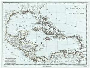
Carte du Golfe du Mexique et des Isles Antilles.
$650.00
Acquire
- Digital Map Information
- Suitable for large format printing
- DPI: 300
- File Size: 6.71 MB
- File Type: ZIP / TIFF
- ICC color profile embedded
- Delivered instantly via download link
This is a strikingly engraved c. 1795 Edme Mentelle and Pierre-Gilles Chanlaire map of the West Indies that is notably printed on high quality light French Revolution blue handkerchief paper, which briefly appeared during the French Revolution. The map depicts the region from Central America to the Atlantic Ocean and from the Gulf Coast of the United States to northern South America. Beautifully engraved, myriad locations throughout the region are labeled, including islands, archipelagos, and points and capes along the islands' coastlines. New Orleans and St. Augustine are labeled in the southern United States, along with Charleston (Charles Town) and numerous rivers. Regions in New Spain (Nouvelle Espagne) are labeled, as are towns, lakes, and mountains. (more details)