1795 Mentelle and Chanlaire Map of the West Indies
WestIndies-mentelle-1795$650.00

Title
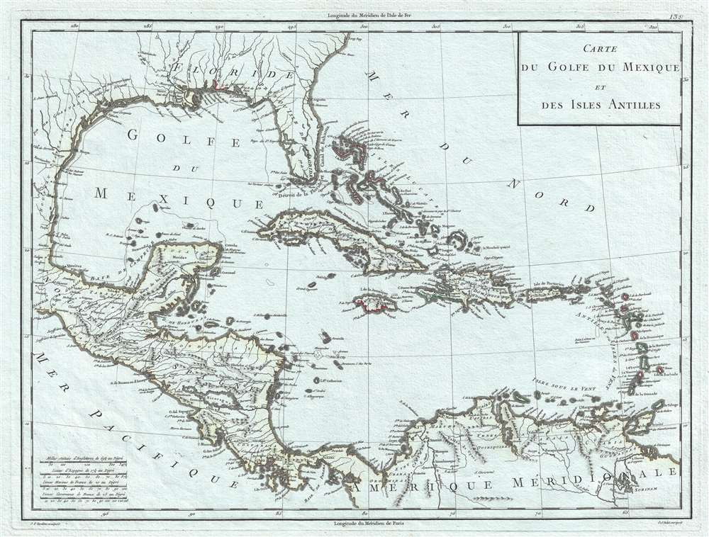
Carte du Golfe du Mexique et des Isles Antilles.
1795 (undated) 14 x 18 in (35.56 x 45.72 cm) 1 : 10168000
1795 (undated) 14 x 18 in (35.56 x 45.72 cm) 1 : 10168000
Description
This is a strikingly engraved c. 1795 Edme Mentelle and Pierre-Gilles Chanlaire map of the West Indies that is notably printed on high quality light French Revolution blue handkerchief paper, which briefly appeared during the French Revolution. The map depicts the region from Central America to the Atlantic Ocean and from the Gulf Coast of the United States to northern South America. Beautifully engraved, myriad locations throughout the region are labeled, including islands, archipelagos, and points and capes along the islands' coastlines. New Orleans and St. Augustine are labeled in the southern United States, along with Charleston (Charles Town) and numerous rivers. Regions in New Spain (Nouvelle Espagne) are labeled, as are towns, lakes, and mountains.
French Blue Paper
The map is printed on fine laid paper with a distinctly blue tint. Blue papers appear in Europe as early as the 15th century, but rose exponentially in popularity in the second half of the 18th century. At the time, papermills collected used rags, which were the broken down into fibers and processed into paper - hence the term 'rag paper'. Blue dies were popular in the European fine-textile industry - particularly among the elite who used blue fabrics for table linens, bed linens, and clothing. Blue dies were less fugitive than other colors, and so were preserved through the papermaking pulpification process. During the French Revolution, the expansive linen closes of the nobility were raided with many of the fine textiles finding their way into papermills. This led to a surplus of blue cloth. Papermakers began experimenting with adding small amounts of blue pulp to stand bleached white pulps, to even out the color and tone - often leading to fine papers with a striking bluish cast - as here. By the end of the 18h century, the fashion for blue paper declined considerably in favor of more traditional white papers. Today maps produced from French Revolution blue paper are highly desirable.Publication History and Census
This map was engraved by Pierre Francois Tardieu and P. J. Valet and published by Edme Mentelle and Pierre-Gilles Chanlaire c. 1795.CartographerS
Edme Mentelle (October 11, 1730 - April 28, 1816) was a French geographer and historian active in Paris during the late 18th century. Mentelle was born in Paris in 1730. He studied under the historian Jean-Baptiste Louis Crevier at the College of Beauvais before accepting a position as professor of Geology and History at the Ecole Militaire where, incidentally, he tutoring the young Napoleon Bonaparte. He remained in this position until the institution was abolished in 1792. Mentelle later worked as a private tutor and then as a professor of Geography at the Ecole Normale. From 1795 he was a member of the Institut National des Sciences et des Arts, which he helped to found. Mentelle published a number of importantly geographical works including the 1778 Geographie Comparee, the 1779 Atlas Universel, and the 1801 Cours Complet de Cosmographie, de Chronologie, de Geographie et d'Histoire. He is known to have worked with Conrad Malte-Brun, Ambrose Tardieu, Peter Simon Pallas, and other important cartographic figures of his period. Edme Mentelle is frequently erroneously confused with Francois Simon Mentelle, another French Geographer who worked with Cassini on his historic survey of France. More by this mapmaker...
Pierre-Gilles Chanlaire (June 21, 1758 - March 8, 1817), also known as Pierre Grégoire Chanlaire, was a French geographer who worked for the Bureau of Topography and Land Registry. He married Angélique-Émilie Vermeil on April 26, 1787 with whom he had two children. Learn More...
Pierre François Tardieu (1711 - 1771) was a French engraver and mapmaker active in Paris during the middle part of the 18th century and a member of the large and prolific Tardieu family. Several members of the family established themselves as engravers, and, for over 200 years, the family produced works. Pierre Francois Tardieu was born around 1711 in Paris, son of Jean Tardieu. His uncle, Nicolas-Henry Tardieu, taught him the art of engraving. Pierre was a general engraver whose work was not limited to maps but also included historical and genre works. Many of his maps are extremely significant and include some of the finest French productions of the period. Tardieu had his office at Rue de al Corderie, Paris. Tardieu was married to Marie-Anne Rousselet (1733-1826), whose family included the engraver Gilles Rousselet and the sculptor Jean Rousselet. It is highly likely that Pierre Francois Tardieu was succeeded by Pierre Antoine Francois Tardieu (1757 - 1822), who is also possibly his son, as the latter continued to engrave under the P. F. Tardieu imprint well after the former's death. Learn More...
Condition
Very good. Even overall toning. Printed on French Revolution blue handkerchief paper. Blank on verso.
References
Boston Public Library Normon B. Leventhal Map Center G4900 1797 .C37x.