
Corning, Amos

Amos Corning (17?? - 1837) was a New York surveyor active in the late 18th and early 19th centuries. He performed both commercial and government surveys, most of which date to the first decades of the 19th century. He was appointed official city surveyor in 1808, replacing William Bridges. He was married to Aletta Burtis (1762 - 18??).
Earliest map of Tribeca?
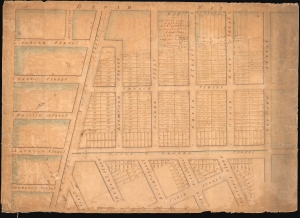
Map of Part of the Estate belonging to the Heirs of Anty Lispenard Decd. Situate to the South Ward of Canal Street New York.
$2,750.00
Acquire
- Digital Map Information
- Suitable for large format printing
- DPI: 600
- File Size: 70.94 MB
- File Type: ZIP / TIFF
- ICC color profile embedded
- Delivered instantly via download link
This unique c. 1801 manuscript map is likely the earliest to specifically illustrate modern-day Tribeca, New York City. The survey dates to 1801, but this manuscript copy was likely drawn around 1808-1809 when the author Amos Corning held the office of City Surveyor. It details lands owned by Anthony Lispenard Bleecker (1741 - 1816), here subdivided into properties, on some of which landholders are identified. (more details)