1801 Amos Corning Manuscript Survey Map of Tribeca, New York City
TribecaLispenard-amoscorning-1801$2,750.00

Title
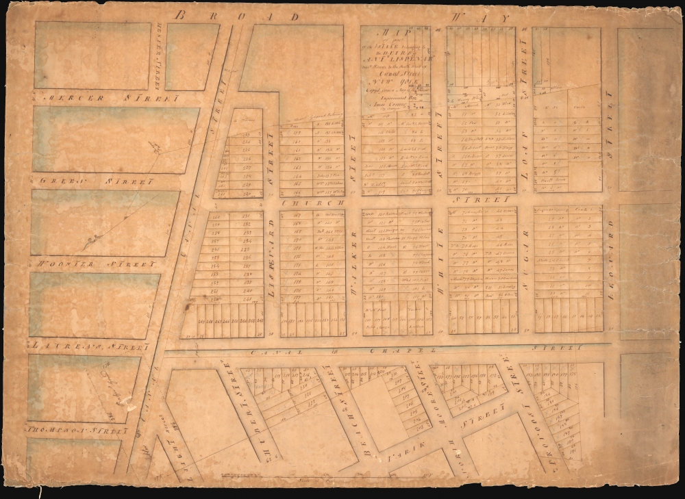
Map of Part of the Estate belonging to the Heirs of Anty Lispenard Decd. Situate to the South Ward of Canal Street New York.
1801 (undated) 21 x 29 in (53.34 x 73.66 cm) 1 : 800
1801 (undated) 21 x 29 in (53.34 x 73.66 cm) 1 : 800
Description
This unique c. 1801 manuscript map is likely the earliest to specifically illustrate modern-day Tribeca, New York City. The survey dates to 1801, but this manuscript copy was likely drawn around 1808-1809 when the author Amos Corning held the office of City Surveyor. It details lands owned by Anthony Lispenard Bleecker (1741 - 1816), here subdivided into properties, on some of which landholders are identified.
The street layout of Tribeca was roughly put together in the late 1700s. The absence of any reference to St. John's Chapel, constructed in 1803, as evident on our other manuscript map of this area (Tribeca-loss-1801), suggests this map must predate those plans. Contemporaneous illustrations of the area reveal open tree-filled lands all around. Most of the latter development of this area followed the 1811 filling of Collect Pond.
A Closer Look
The map is oriented to the southeast. Broadway runs along the top; at the northeasternmost point (left) is Grand Street (unlabeled), the southwesternmost limit (right) is Leonard Street, and along the bottom, running north-south, is Varick Street. Canal Street, as labeled here, is modern-day West Broadway. Hester Street, in the top left, is roughly modern-day Howard.A Nice Country Estate
Bleeker acquired this property in 1801, during which time he was a prominent banker, merchant, auctioneer, and one of the richest men in New York. According to the 1884 obituary of his grandson Anthony J. Bleeker, he remembers his grandfather returning home one day and proudly announcing he acquired some 160 acres 'out in the country'. That vast tract of land eventually evolved into modern-day Tribeca and Greenwich Village. Here, Lispenard Street is named after him.The street layout of Tribeca was roughly put together in the late 1700s. The absence of any reference to St. John's Chapel, constructed in 1803, as evident on our other manuscript map of this area (Tribeca-loss-1801), suggests this map must predate those plans. Contemporaneous illustrations of the area reveal open tree-filled lands all around. Most of the latter development of this area followed the 1811 filling of Collect Pond.
Publication History and Census
Manuscript copied from a survey logged with the city clerk's office by City Surveyor Amos Corning, likely around 1808-9. Only known example.Cartographer
Amos Corning (17?? - 1837) was a New York surveyor active in the late 18th and early 19th centuries. He performed both commercial and government surveys, most of which date to the first decades of the 19th century. He was appointed official city surveyor in 1808, replacing William Bridges. He was married to Aletta Burtis (1762 - 18??). More by this mapmaker...
Condition
Average. Edge Wear. Soiling right side. Overall toning.