
Desbruslins, François

François Desbruslins (1709 - 17xx) was a French map and line engraver active in Paris during the mid-18th century, from approximately 1719 until 1757. His is known for architectural plans, maps, and scientific diagrams. He engraved numerous maps for several famous French cartographers, including Philippe Buache and Jacques-Nicolas Bellin.
Pioneering Effort in Oceanic geography.
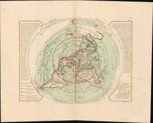
Planisphere Physique.
$1,200.00
Acquire
- Digital Map Information
- Suitable for large format printing
- File Size: 42.7 MB
- File Type: ZIP / TIFF
- ICC color profile embedded
- Delivered instantly via download link
A fascinating and beautiful 1781 Philippe Buache map of the world, presented on an unusual polar projection rendered from the North Pole. This is the first work to attempt to map the ocean floor - a revolutionary work connecting submarine with surface geography. Although Buache's geography was speculative at best, the work is a landmark achievement in its attempt to illustrate and scientifically assess the unknowable oceanic depths. (more details)
Pioneering submarine geography.
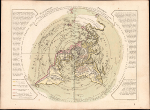
Planisphere Physique.
$1,200.00
Acquire
- Digital Map Information
- Suitable for large format printing
- Full resolution TIFF file
- ICC color profile embedded
- Delivered instantly via download link
A striking 1781 Philippe Buache map of the world, presented on an unusual polar projection rendered from the North Pole. This is the first work to attempt to map the ocean floor - a revolutionary work connecting submarine with surface geography. Although Buache's geography was speculative at best, the work is a landmark achievement in its attempt to illustrate and scientifically assess the unknowable oceanic depths. (more details)