
Desbruslins, François (sold)

François Desbruslins (1709 - 17xx) was a French map and line engraver active in Paris during the mid-18th century, from approximately 1719 until 1757. His is known for architectural plans, maps, and scientific diagrams. He engraved numerous maps for several famous French cartographers, including Philippe Buache and Jacques-Nicolas Bellin.
1st geological map of the United States.
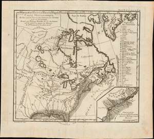
Carte minéralogique, où l'on voit la Nature des Terreins du Canada et de la Louisiane.
sold
- Digital Map Information
- Suitable for large format printing
- Full resolution TIFF file
- ICC color profile embedded
- Delivered instantly via download link
An object of considerable rarity and significance, this is the first geological map of the United States, drawn by Philippe Buache and published in 1752 by Jean-Étienne Guettard. The map covers the eastern part of the modern-day United States and Canada from the Rio del Norte (Rio Grande) and the apocryphal 'Mer de L'Ouest' (Sea of the West) to the Atlantic seaboard, Greenland, and the Grand Banks. The map was part of Guettard's curious presentation issued at the Paris Académie Royale des Sciences comparing the geography of North America to the geography of Switzerland. The report also contained, therefore, the first geological map of Switzerland. (more details)
Innovative, if incorrect, theories about the world's mountain ranges.
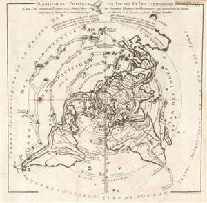
Planisphere Physique où l'on voit du Pole Septentrional ce que l'on connoit de Terres et de Mers; Avec les Grandes Chaînes de Montagnes qui traversent le Globe.
sold
- Digital Map Information
- Suitable for large format printing
- Full resolution TIFF file
- ICC color profile embedded
- Delivered instantly via download link
This is a beautiful 1752 Philippe Buache map of the world represented on an unusual polar projection rendered from the North Pole. The map covers from the North Pole Arctic region south beyond Tasmania (Van Diemen's Land) to include parts of New Zealand and even Cap de la Circoncision (Bouvet Island). (more details)