
Erkan-i Harbiye-i Umumiye Matbaası

Erkan-i Harbiye-i Umumiye Matbaası (اركان حربيه عموميه مطبعه سى ; fl. c. 1899 – 1927) was an Istanbul-based publisher of the late Ottoman and early Republican eras affiliated with the Turkish military's General Staff. Modeled heavily on the Prussian system, its primary mandate was to publish the materials required to run the empire's active military machine, from operational maps to regulations, strategic directives, intelligence reports, and translations of foreign military doctrines. Rather than being aimed at the general public or even government officials, its audience was the active officer corps, field commanders, and the high command. The documents it produced were often restricted, meant for internal circulation among commissioned officers and general staff planners.
Ottoman map of Istanbul's defenses on the eve of World War I.
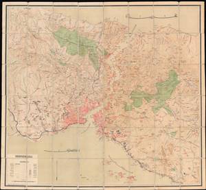
Istanbul ve Boğazı ve civarı haritası / [Map of Istanbul, the Bosphorus, and Surroundings].
$2,000.00
Acquire
- Digital Map Information
- Suitable for large format printing
- File Size: 73.41 MB
- File Type: ZIP / TIFF
- ICC color profile embedded
- Delivered instantly via download link
This is a rare c. 1911 (1327 AH) large-scale folding Ottoman map of Istanbul, the Bosporus, and environs. This map was published by a military-affiliated publisher amid multiple crises in the European portion of the Ottoman Empire. Its ready foldability suggests that it was intended for use in the field, perhaps preparing fortifications in the event of an attack on the city. (more details)
Walls of the Sea.
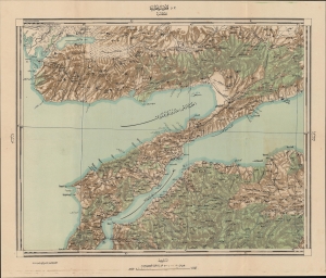
قلعه سلطانيه / [Sultaniye Castle].
$950.00
Acquire
- Digital Map Information
- Suitable for large format printing
- Full resolution TIFF file
- ICC color profile embedded
- Delivered instantly via download link
This is a 1922 Ottoman Turkish military and topographic map of the Dardanelles, produced by the Erkan-ı Harbiye-i Umumiye Matbaası. It highlights fortifications, lines of communication, and other essential military information constructed just before and during World War I (1914 - 1918), preparations that would pay off during the Gallipoli Campaign in 1915. (more details)
Baghdad in Transition from Ottoman to British Rule.
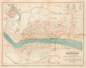
بغداد شهری / [City of Baghdad].
$3,500.00
Acquire
- Digital Map Information
- Suitable for large format printing
- File Size: 18.69 MB
- File Type: ZIP / TIFF
- ICC color profile embedded
- Delivered instantly via download link
This is a rare c. 1925 Ottoman Turkish map of Baghdad, originally prepared by Rashid (Reşid) Bey and updated by the Erkân-ı Harbiye-i Umûmiye Matbaasından, the Printing House of the General Staff of the Turkish military. Although published after the city's capture by British forces, the map presents the city at the end of the Ottoman period, with references to its earlier history. (more details)