This item has been sold, but you can get on the Waitlist to be notified if another example becomes available, or purchase a digital scan.
1777 Brion de La Tour Map of New York and New England (American Revolutionary War)
TheatredelaGuerre-briondelatour-1779$2,750.00

Title
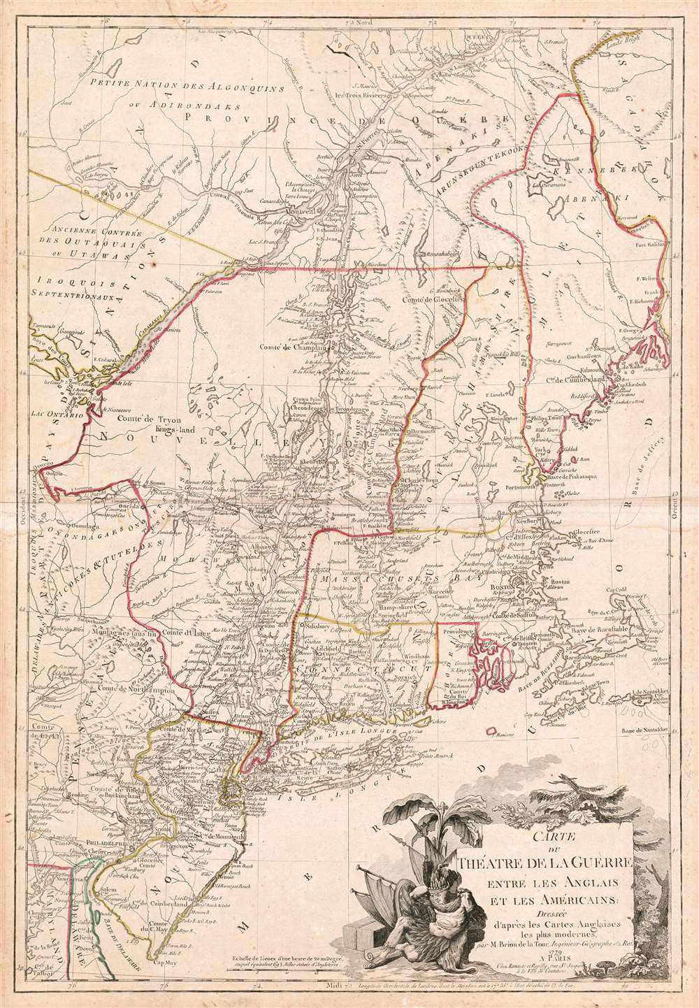
Carte du Theatre de la Guerre entre les Anglais et Les Americains.
1779 (dated) 29.5 x 20 in (74.93 x 50.8 cm) 1 : 1200000
1779 (dated) 29.5 x 20 in (74.93 x 50.8 cm) 1 : 1200000
Description
This is a scarce, separately published American Revolutionary War map of New York and New England. First issued by Brion de la Tour in 1777, this map was intended to illustrate the important events at the height of the war. Brion de la Tour's map covers from the Delaware and Chesapeake Bays northward as far as Quebec City, inclusive of New York (with modern day Vermont), New Jersey, Massachusetts, Connecticut, New Hampshire, and parts of Pennsylvania, Maryland, Delaware, Maine, and Canada. It offers both political and topographical detail including mountains, rivers, roadways, regional boundaries, American Indian nations, towns, and cities.
Keeping Courant with the War
The significance of this map stems not only from its sophisticated cartographic representation of the region, but also for its notations regarding the October 16th Battle of Saratoga and the subsequent surrender of the British Army under General John Burgoyne. Considered to be the major turning point in the American Revolutionary War (1775 - 1783), the Battle of Saratoga was precipitated when General Burgoyne led a large force of British and German soldiers through parts of New York and New England with the intention of dividing New England from the southern theater of war. In a series of strategic maneuvers American soldiers under Horatio Gates and Benedict Arnold (before he changed sides) surrounded Burgoyne at Saratoga, forcing his surrender. This event, beautifully illustrated in this French map of the area, convinced the French King Louis XV to officially support the American Revolutionary efforts. By joining the Revolutionary War on the side of the Americans, the French and later the Spanish, turned the war from an internal matter between Britain and its colonies into a global conflict.Publication History and Census
Several editions of this map appeared in 1777, 1778, 1779 and in a reduced size in 1782. This map is the first published illustration of the Battle of Saratoga to appear in France and responded directly to French interest in the American Revolutionary War associated with their subsequent involvement. Although most known examples exhibit a centerfold, like this one, Brion de La Tour's map of the Theater of War in America was a separate issue and not associated with any specific publication. Drawn by Brion de La Tour and published by Esnauts et Rapilly from their offices on Rue St. Jacques a la Ville de Coutances. Only seven examples of this 1779 edition of the map are cataloged in OCLC.CartographerS
Louis Brion de la Tour (1743 - 1803) was the Cartographer Royal to the King of France, his official title being Ingenieur-Geographe du Roi. Despite a prolific cartographic career and several important atlases to his name, little is actually known of his life and career. He may have been born in Bordeaux. His son of the same name was born in 1763 and published until his death in 1832. It is nearly impossible to distinguish the work of the father from the work of the son, as both used the same imprint and were active in roughly the same period. Much of their work was published in partnership Louis Charles Desnos (fl. 1750 - 1790). Their most notable work is generally regarded to be his 1766 Atlas General. More by this mapmaker...
Esnauts and Rapilly (fl. c. 1775 - 1811) were Paris based print sellers and publishers active in the latter part of the 18th century. The firm was founded by Jacques Esnauts and Michel Rapilly. Esnauts and Rapilly are best known not for their cartographic works, but rather for their fashion prints. The important publication La Galerie des Modes highlighted the fashions of the French aristocracy just prior to the French Revolution and is considered to be the first published "fashion magazine". At this time, Paris was the center of the fashion world and Esnauts and Rapilly's plates were widely distributed to eager fashionistas the world over. The firm also published a number of important and influential maps including several depicting pivotal moments in the American Revolutionary War. Not wanting to miss out on potential customers, Esnauts and Rapilly gave exact directions to their bookshop on many of their publications: "at the Baker's shop, opposite the Cutler." Learn More...
Condition
Very good. Even overall toning. Wide margins all around. Slight marginal soiling, else excellent. Original outline color.
References
OCLC 5569421. McCorkle, B. B., New England in Early Printed Maps 1513-1800: An Illustrated Carto-Bibliography, 777.6. Nebenzahl, Kenneth, A Bibliography of Brinted Battle Plans of the American Revolution, 1775-1795, 121. Library of Congress, Map Division, G3710 1777 .B71 Vault. Sellers, J. R., and Van Ee, P. M., Maps and Charts of North America and the West Indies 1750-1789, 728.