
Federated Malay States Survey

Federated Malay States Survey (1922 - 1945), better known as the F.M.S. Survey Department, was established in the early 20th century to produce detailed surveys of British Malaya and the Straits Settlements. The survey department had offices in most major Malayan ports, including Singapore, Kuala Lumpur, Penang (Georgetown), and Malacca. They were the first official survey organization to publish detailed scientifically produced maps of the region.
Tin and Rubber Booms.
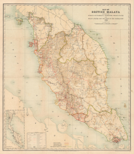
Map of British Malaya including the Straits Settlements Federated Malay States and Malay States Not Included in the Federation.
$1,500.00
Acquire
- Digital Map Information
- Suitable for large format printing
- File Size: 20.62 MB
- File Type: ZIP / TIFF
- ICC color profile embedded
- Delivered instantly via download link
This scarce 1920 map of Malaya (modern-day Malaysia), issued by the Surveyor General of the Federated Malay States, captures the peninsula at a pivotal moment in its colonial and economic history - some 13 years after Britain assumed control of the northern Malay states from Siam and incorporated them as the Unfederated Malay States. Produced during the early years of the region's tin and rubber booms, this map reflects both British administrative ambition and the accelerating transformation of Malaya into one of the most productive territories in Southeast Asia. (more details)
Malaya Road Network.
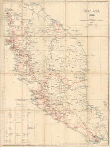
Malaya 1930. / F. M. S. Surveys No. 277 - 1930. / Motoring Map of Malaya.
$1,200.00
Acquire
- Digital Map Information
- Suitable for large format printing
- File Size: 32.14 MB
- File Type: ZIP / TIFF
- ICC color profile embedded
- Delivered instantly via download link
This is a rare 1930 map of Malaya (Malaysia), along with the Straits Settlements (Malacca, Penang, Singapore, Dinding), issued by the Surveyor General of the Federated Malay States (FMS). It was produced to highlight the road network, and particularly the growing automobile road network, on the Malay Peninsula. (more details)