
1930 F. M. S. Map of Malaya (Malaysia) and Singapore

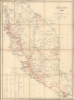

Malaya 1930. / F. M. S. Surveys No. 277 - 1930. / Motoring Map of Malaya.
Malaya Road Network.
$1,200.00
Choose a Collection:
- Digital Map Information
- Suitable for large format printing
- File Size: 32.14 MB
- File Type: ZIP / TIFF
- ICC color profile embedded
- Delivered instantly via download link
This Item
Enquire
Malaya Road Network.
This is a rare 1930 map of Malaya (Malaysia), along with the Straits Settlements (Malacca, Penang, Singapore, Dinding), issued by the Surveyor General of the Federated Malay States (FMS). It was produced to highlight the road network, and particularly the growing automobile road network, on the Malay Peninsula.A Closer Look
The map covers the Malay peninsula from the Thai/Siamese border to Singapore. This is a topographical map drawn to illustrate the developing road system. Roads, both extant and under construction, are highlighted in red. The map also details railway lines, cart tracks, light railways, and state boundaries. Hotels, rest houses, and golf courses are also identified. A table in the lower left identifies distances from Kuala Lumpur, wireless stations, and meteorological stations.Roads of the FMS
In 1930, the roads of the Federated Malay States (FMS) were an expanding network crucial to regional economic development, particularly in the tin mining and rubber industries. The road system primarily consisted of narrow, gravel, or laterite roads that connected major towns, mining areas, rubber estates, and ports. These roads facilitated the movement of goods and resources, contributing significantly to trade within the states of Selangor, Perak, Negeri Sembilan, and Pahang. While main roads were relatively well-maintained to support burgeoning automobile usage, rural areas still faced limited access with basic dirt paths. Despite the challenges of maintaining roads in the tropical climate, the network continued to grow, symbolizing the region's efforts to modernize and boost economic activity during the British colonial period. These roads would become a critical battleground during the Second World War, as British scorched earth tactics sought to inhibit Japan's lightning invasion of Malaya in December 1941.Publication History and Census
This map was prepared by the Federated Malay States Survey in 1930. It is rare, cataloged at only the National Library Board in Singapore and the Academia Sinica. The map was issued in several editions between 1926 and 1938 (see our earlier listing MalayaSingapore-fms-1933), all of which are rare in both institutional collections and market history.Cartographer
Federated Malay States Survey (1922 - 1945), better known as the F.M.S. Survey Department, was established in the early 20th century to produce detailed surveys of British Malaya and the Straits Settlements. The survey department had offices in most major Malayan ports, including Singapore, Kuala Lumpur, Penang (Georgetown), and Malacca. They were the first official survey organization to publish detailed scientifically produced maps of the region. Further Details...
Condition
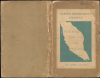
Very good. Dissected and laid on linen. Original binder.
References
OCLC 298425089, 1463510612.