
Freytag and Berndt

Freytag and Berndt (1770 - Present) is a map, atlas, guidebook, and travel literature publisher. Its roots reach back to when Francesco Artaria founded a lithographic works in Vienna in 1770. In February 1879, Gustav Freytag founded a cartographic publishing house. Freytag and Berndt merged with the cartographic division of Artaria in 1920. After World War II, Freytag-Berndt und Artaria experienced expanded publication to become one of the most important cartographic publishers in Central Europe. Today, Freytag and Berndt publishes street maps, city map, hiking maps, and cycling maps and employs fifty cartographers and editors at their headquarters in Vienna.
Stomping Grounds of Freud, Mahler, Klimt, Zweig, and Herzl.
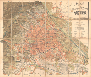
Plan der Reichshaupt und Residenzstadt Wien mit Angabe der neuen Bezirkseintheilung und der früheren Gemeindegrenzen.
$800.00
Acquire
- Digital Map Information
- Suitable for large format printing
- File Size: 1459.94 MB
- File Type: ZIP / TIFF
- ICC color profile embedded
- Delivered instantly via download link
This 1897 chromolithographed large-format folding map of Vienna was prepared by Freytag and Berndt for publication by A. Hartleben's Verlag. It presents the city during a period of drastic transformation when it had become one of the most dynamic intellectual and artistic centers in the world. (more details)
Rise of Alpine cartography.
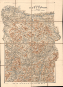
G. Freytag's Übersichtskarte der Dolomiten. Blatt 2.
$350.00
Acquire
- Digital Map Information
- Suitable for large format printing
- File Size: 56.08 MB
- File Type: ZIP / TIFF
- ICC color profile embedded
- Delivered instantly via download link
This is Gustav Freytag's 1902 large-format topographic map of the Dolomite Mountains of the European Alps, spanning the border region between Austria and Italy. It represents an early example of the first great age of Alpine cartography, pioneered by Freytag employee Hans Rohn, that coincided with the increasing popularity of Alpine clubs like the Deutscher und Österreichischer Alpenverein. (more details)