This item has been sold, but you can get on the Waitlist to be notified if another example becomes available, or purchase a digital scan.
1910 Freytag Folding Map of the Eastern Dolomites, Italy
DolomitenEast-freytag-1910$100.00

Title
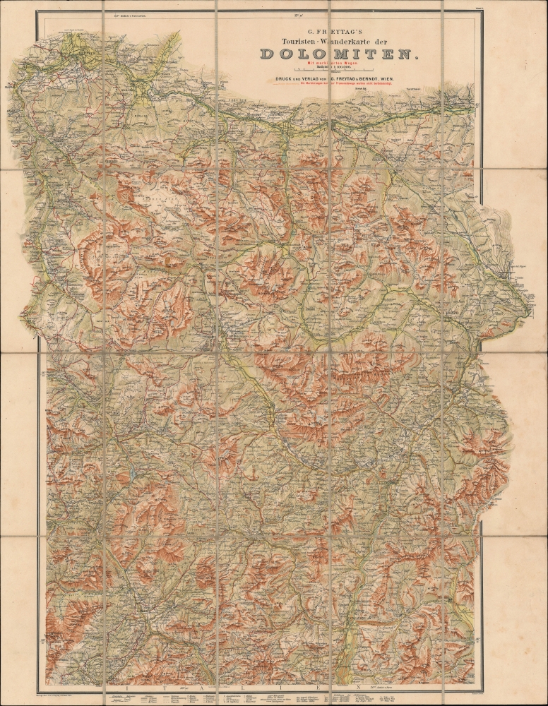
G. Freytag's Touristen-Wanderkarte der Dolomiten mit markierten Wegen. Blatt 2.
1910 (undated) 28.5 x 21.5 in (72.39 x 54.61 cm) 1 : 100000
1910 (undated) 28.5 x 21.5 in (72.39 x 54.61 cm) 1 : 100000
Description
An impressive c. 1910 folding topographic map of the eastern portion of the Dolomites, then a part of Austria. It was produced by Freytag und Berndt in Vienna, the premier publisher of such topographical maps in Austria at the time.
A Closer Look
This map covers the eastern portion of the Dolomites, roughly corresponding to the eastern portion of today's province of Alto Adige (Südtirol in German). Characteristic of the Freytag-Berndt style, the map is highly detailed, appealing to tourists, hikers, and others who would need an intimate knowledge of topography and other features in the steep mountainous terrain. Villages, towns, and even individual buildings are noted, more often with local Italian names, but increasingly with local German names as one moves northwards. Railways, roads, paths, and trails of various types and quality (classes) are indicated according to the legend at bottom. Churches, chapels, and other local landmarks are recorded, while elevation is given throughout. A table of abbreviations with corresponding terms in German and Italian appears at bottom-right.Historical Context
The map reflects the multiculturalism of the Austrian Empire, or its illegitimate control over these lands, depending on one's perspective. At the time, this region was the southern portion of the County of Tyrol, part of the Austrian Empire. During the First World War, lands just to the south were the front line of intense high-altitude combat between Italian and Austrian forces, and after the war Südtirol was annexed by Italy, completing, in the minds of many nationalists, the project of Italian Unification begun roughly a century before.Publication History and Census
This map is attributed to Gustav Freytag and was published by Freytag und Berndt in Vienna, with H. Rohn providing terrain detail. Though undated, from the railways present, the map must date to after 1907, but before 1918, when Austria ceded these lands to Italy. The present map (Blatt 2) was meant to accompany a map of the western portion of the Dolomites (Blatt 1), also sold by us. The maps might have been issued in several editions, though the variation of dates in catalog listings may simply be due to a lack of a date on the map and uncertainty over its approximate date of production. In any event, the maps are held by a handful of institutions in Europe and North America, though usually as a standard folding map instead of the present format, dissected and laid on linen (another example of which we have only been able to locate at Yale's Beinecke Library).Cartographer
Freytag and Berndt (1770 - Present) is a map, atlas, guidebook, and travel literature publisher. Its roots reach back to when Francesco Artaria founded a lithographic works in Vienna in 1770. In February 1879, Gustav Freytag founded a cartographic publishing house. Freytag and Berndt merged with the cartographic division of Artaria in 1920. After World War II, Freytag-Berndt und Artaria experienced expanded publication to become one of the most important cartographic publishers in Central Europe. Today, Freytag and Berndt publishes street maps, city map, hiking maps, and cycling maps and employs fifty cartographers and editors at their headquarters in Vienna. More by this mapmaker...
Condition
Very good. Panels mounted on linen. Light soiling and foxing on margins.
References
OCLC 494982094.