1902 Freytag Topographic Map of the Dolomites, Italy - Austria Borderland
Dolomites-freytag-1902$350.00

Title
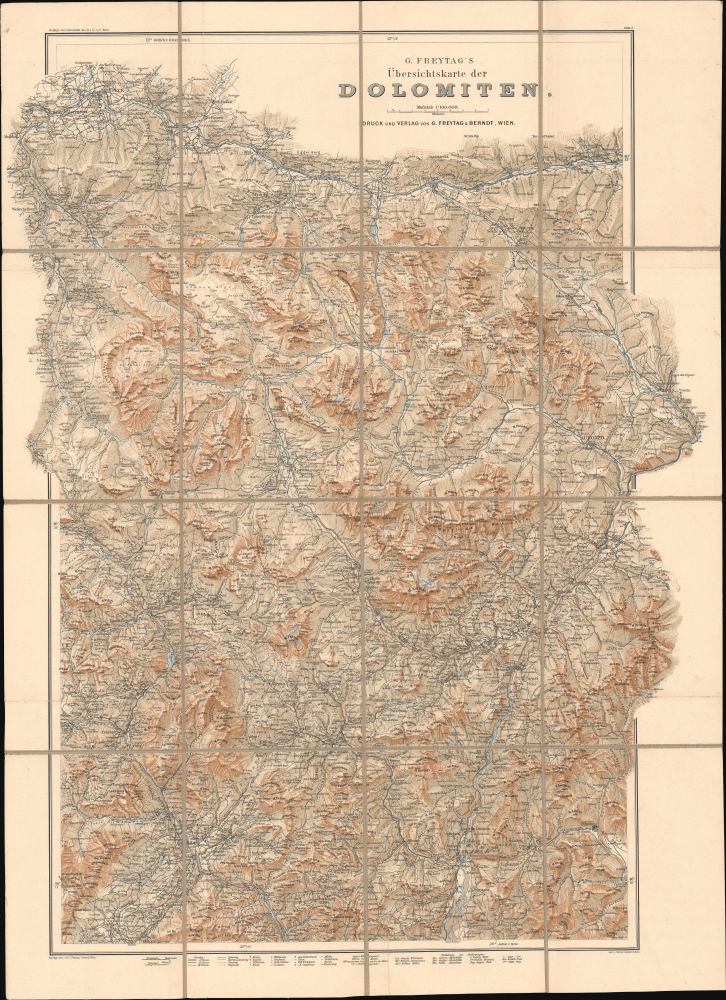
G. Freytag's Übersichtskarte der Dolomiten. Blatt 2.
1902 (undated) 30.75 x 22.5 in (78.105 x 57.15 cm) 1 : 100000
1902 (undated) 30.75 x 22.5 in (78.105 x 57.15 cm) 1 : 100000
Description
This is Gustav Freytag's 1902 large-format topographic map of the Dolomite Mountains of the European Alps, spanning the border region between Austria and Italy. It represents an early example of the first great age of Alpine cartography, pioneered by Freytag employee Hans Rohn, that coincided with the increasing popularity of Alpine clubs like the Deutscher und Österreichischer Alpenverein.
Aside from the international boundary, many other features are indicated, including towns and villages, individual buildings, roads of several classes, railways, footpaths, mule tracks, churches, chapels, observation towers, inns, hunting lodges, and of course topographic details like waterways, terrain, and elevation. A legend and table of abbreviations appears at bottom.
The present edition of the map is cataloged, either independently or with the western sheet, at about fifteen institutions in the OCLC, all of which are in Europe except for Cornell University.
A Closer Look
Coverage includes a large portion of what is now Belluno Province and Trentino-Alto Adige (Südtirol) Province in Italy. At the time of this map's preparation, the Südtirol portion of the map, at left, was part of the Austro-Hungarian Empire, while the Belluno side at right had become part of the Kingdom of Italy in 1866. That being said, although the international border is marked at several points, it is hardly emphasized here, and both German and Italian names are employed, sometimes for the same feature.Aside from the international boundary, many other features are indicated, including towns and villages, individual buildings, roads of several classes, railways, footpaths, mule tracks, churches, chapels, observation towers, inns, hunting lodges, and of course topographic details like waterways, terrain, and elevation. A legend and table of abbreviations appears at bottom.
Alpine Adventures
This map and much of the other work produced by Rohn and Freytag both helped launch and reinforce the trend for recreational Alpine hiking that took off in the 1860s. Alpine clubs were founded in quick succession in Germany and Austria (merged in 1873 as the Deutscher und Österreichischer Alpenverein), Switzerland, France, and Italy. Based in Vienna, Freytag (later Freytag and Berndt) developed a niche printing highly-detailed and realistic folding maps for hikers, thanks in large part to lithographic engraver Hans Rohn (see biography below). Love of the mountains (which themselves spanned borders), of mastering challenging summits, and of scientific curiosity (geology, glaciology, botany) tied together enthusiasts of different nations, but the hobby could also be used to reinforce nationalism and discrimination, particularly against Jews, who were excluded from many local sections of the DuÖAV.Publication History and Census
This map was prepared by J. Drobny with terrain by Hans Rohn for the publisher Freytag and Berndt as a special supplement to the 1902 issue of the Zeitschrift des Deutschen und Oesterreichischen Alpenvereins. It is the eastern sheet (Blatt) of a two-sheet map of the Dolomites (confusingly, the western sheet, Blatt 1, was published after Blatt 2 in the 1903 edition of the Zeitschrift). The two sheets are sometimes cataloged together but often separately, which has led to some unclear cataloging. These 1902 maps appear to be a predecessor edition of the 1910 set of maps of the Dolomites (previously sold by us) titled 'G. Freytag's Touristen-Wanderkarte der Dolomiten.'The present edition of the map is cataloged, either independently or with the western sheet, at about fifteen institutions in the OCLC, all of which are in Europe except for Cornell University.
CartographerS
Freytag and Berndt (1770 - Present) is a map, atlas, guidebook, and travel literature publisher. Its roots reach back to when Francesco Artaria founded a lithographic works in Vienna in 1770. In February 1879, Gustav Freytag founded a cartographic publishing house. Freytag and Berndt merged with the cartographic division of Artaria in 1920. After World War II, Freytag-Berndt und Artaria experienced expanded publication to become one of the most important cartographic publishers in Central Europe. Today, Freytag and Berndt publishes street maps, city map, hiking maps, and cycling maps and employs fifty cartographers and editors at their headquarters in Vienna. More by this mapmaker...
Hans Rohn (February 25, 1868 - December 23, 1955), born Johann Rohn, was a Viennese cartographer, lithographer, and painter best known for his stunning depictions of the European Alps, being a pioneer in the genre of Alpine cartography which flourished in the 20th century. Born in Hundstrum, then a suburb of Vienna, Rohn's talent for drawing was discovered at a young age by the landscape painter and family friend Ferdinand Mayer. In 1882, Rohn began an apprenticeship with the Viennese cartographer and lithographer Gustav Freytag (1852 - 1938). Freytag nurtured Rohn's talent for depicting rocks and terrain and allowed him to develop his own style that resulted in remarkably realistic lithographic prints that appeared almost three dimensional (he eschewed hachure lines, for instance, instead using his artistic instincts to illustrate relief). Freytag had Rohn accompany him on exploratory trips to the Alps to produce the company's very successful Special-Touristenkarten and Touristen-Wanderkarte der Dolomiten series, and also encouraged him to formally study painting and photography. In addition to his cartographic work for Freytag, Rohn also painted landscapes during their Alpine expeditions. In 1889, Rohn entered the Akademie der bildenden Künste to begin a four-year course of study. His teachers included painters Carl Rahl, Siegmund L'Allemand, Leopold Carl Müller; and the portrait and landscape painter Franz Rumpler, who had a particular influence on Rohn. His classmates included painters who would go on to be leading figures in the Vienna Secession movement, related to Art Nouveau. In 1895, Rohn met Theresia Czokally who would become his wife; they had two children together. After finishing his studies at the Akademie der bildenden Künste, Rohn returned to Freytag (now known as Freytag and Berndt) and continued to hone his craft depicting terrain. He also ventured into making three-dimensional raised relief plaster maps of mountainous regions of the Austro-Hungarian Empire. In the first two decades of the 20th century, Rohn did the lithographic 'engraving' for a series of maps produced for early Alpine Clubs, covering multiple sub-ranges of the Alps. These were very highly regarded and established his reputation as the master of 'rock engraving' (Felszeichnung or Felssignatur). By the 1920s, he was a leading figure in the developing field of Alpine cartography and influencing a new generation of artists and cartographers, such that the period between 1902 and 1936 is often referred to as the Rohn Era of Alpine cartography. His success allowed him to build a new home for his family in Melk, a picturesque town on the Danube west of Vienna. Even late in life, he continued to produce stunning new maps of mountainous regions as far away as Persia. Learn More...
Condition
Very good. Dissected and laid on linen. Original linen stable.
References
OCLC 248936957, 312443299.