
General Directorate for Survey (مديرية المساحة العامة a)
General Directorate for Survey (مديرية المساحة العامة a ; 1921-present) is an Iraqi government bureaucracy that operates under the Ministry of Water Resources (known as the Ministry of Irrigation before 2003). Its roots trace back to the early 1920s following World War I and the establishment of the modern Iraqi state under British Mandate administration. Originally established as the Survey Department, growing out of a Military Survey Department in Iraq in 1921, its primary objective was to conduct land settlement surveys, register property boundaries (Tapu), establish irrigation networks, and produce standardized civil and military cartography. During the 1920s, Iraq became an early pioneer in the region for integrating aerial photography and photogrammetry to map vast desert terrains and river valleys. By the mid-20th century, under the leadership of key figures like civil engineer and historian Dr. Ahmed Sousa (1900 - 1982, a chief technical expert for many years in the Survey), the department expanded its technical printing presses in Baghdad and published landmark works, including the Atlas of Baghdad (1952) and extensive regional topographies. Following the establishment of the Republic of Iraq in 1958, the institution operated as the General Directorate of Survey within the Ministry of Irrigation and served as the central state authority for geodetic, cadastral, and thematic mapping. Throughout the 1960s and 1970s, its Baghdad presses produced official administrative, tourist, agricultural, and infrastructural maps supporting state-driven agrarian reform and infrastructure planning. Over subsequent decades, the organization evolved through various administrative restructurings and is now renamed the State Commission of Survey (الهيأة العامة للمساحة) but remains the foundational body for Iraq's national geospatial infrastructure and land surveying today.
AKA: مديرية المساحة العامة a
Building Dams and Identity
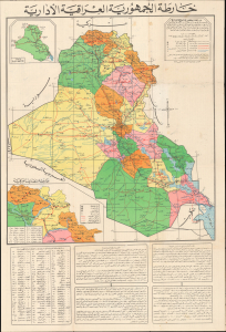
خارطة الجمهورية العراقية الإدارية / [Administrative Map of the Republic of Iraq]. / [Verso title panel] دَلِيل السَّائِح وَالطَّالِب وَالمُوَاطِن فِي خَارِطَة عِرَاقِنَا الحَضَارِي [Guide for the Tourist, Student, and Citizen to the Map of Our Cultural Iraq].
$2,500.00
Acquire
This is a 1972 Arabic-language wall map of Iraq prepared by Tuma Al-Sadi, a high-level bureaucrat in the Ba'athist government, and printed by the General Directorate for Survey. Packed with information, it covers everything from irrigation projects (the main focus of the General Directorate for Survey) to resorts, historical landmarks, tourist riverboats, and other information relevant to tourists. These dual purposes - highly technical on the one hand and leisurely on the other - seem an odd pairing but make sense within the context of the ambitious goals set by the Ba'athists. (more details)