
1972 Al-Sadi Arabic Map of Iraq, Early Ba'athist Era

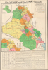
خارطة الجمهورية العراقية الإدارية / [Administrative Map of the Republic of Iraq]. / [Verso title panel] دَلِيل السَّائِح وَالطَّالِب وَالمُوَاطِن فِي خَارِطَة عِرَاقِنَا الحَضَارِي [Guide for the Tourist, Student, and Citizen to the Map of Our Cultural Iraq].
Building Dams and Identity
Building Dams and Identity
This is a 1972 Arabic-language wall map of Iraq prepared by Tuma Al-Sadi, a high-level bureaucrat in the Ba'athist government, and printed by the General Directorate for Survey. Packed with information, it covers everything from irrigation projects (the main focus of the General Directorate for Survey) to resorts, historical landmarks, tourist riverboats, and other information relevant to tourists. These dual purposes - highly technical on the one hand and leisurely on the other - seem an odd pairing but make sense within the context of the ambitious goals set by the Ba'athists.A Closer Look
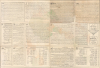
This large sheet is divided into two sections, a map portion covering the top two-thirds and a text portion covering the bottom third. Iraq is divided into governorates (muhafazah), which are color-shaded for easy distinction. A legend at top-right indicates symbols and lines used for roads (paved and unpaved), railways, administrative boundaries, administrative centers at various levels, and waterways (including seasonal wadis). An inset at the top-left shows the country's main roads and distances to important cities in neighboring countries (such as Ankara, Aleppo, and Tehran), while a larger inset at the bottom-left focuses on summer resorts in the northern Kurdistan region, including a table of distances between major resorts.An introductory paragraph explains the dual purpose of the map to both give a 'summary of the most important agricultural projects undertaken by the Revolutionary Government' and 'information needed by the tourist, the student, and the citizen about this dear country.' True to these aims, the sheet contains a wealth of information on both topics. The bottom third of the verso is dedicated to descriptions of major agricultural (that is, irrigation) projects and a large table of distances between cities across Iraq. The verso, meanwhile, focuses on historical landmarks from both Antiquity and the Early Islamic Period, the major museums of Baghdad, and lists of hotels, clinics, youth hostels, swimming pools, and parks in Baghdad, with a small panel on Baghdad's 'Holy Shrines and Famous Mosques,' a significant concession by the secular Ba'athist government.
Historical Context
This map was produced during the early years of the Ba'athist regime in Iraq and reflects two major aims of the new government: improving agricultural output (through large-scale irrigation and land reclamation projects) and boosting a unified national identity to overcome internal ethnic, religious, and tribal divisions. Notably, this map was also issued the same year that the Iraq Petroleum Company was nationalized. Soon afterward, armed with soaring oil revenues, the government funneled profits into crafting a unified national identity that synthesized Arab nationalism with ancient Mesopotamian heritage. To project this identity both domestically and internationally, the government funded archaeological excavations and high-profile restorations at sites such as Babylon, Nineveh, and Ur, framing the modern Ba'athist state as the legitimate successor to ancient civilizational greatness. This ideological drive was paired with state-sponsored tourism initiatives, including the establishment of government travel agencies, modern hotel infrastructure, and resort developments around locations like Lake Habbaniyah (بحيرة الحبانية) and Shaqlawa (شقلاوه), which were designed to promote domestic travel and highlight Iraq's cultural renaissance to foreign visitors.Concurrently, the government executed extensive infrastructure modernization programs centered on grand hydraulic engineering to achieve agricultural self-sufficiency and consolidate state control over rural regions. The early 1970s saw a major expansion of irrigation networks, highlighted by the construction of the Lake Tharthar canal system to manage water flow between the Tigris and Euphrates rivers, prevent seasonal flooding, and secure reliable water supplies for downstream crops. Alongside these massive canal and dam projects, the state implemented widespread land reclamation drives to combat soil salinization, installed modern drainage networks, and expanded rural electrification, dramatically increasing arable land while firmly integrating agricultural communities into the nationalized economy.
Publication History and Census
This map was prepared by Tuma Al-Sadi (طعمة السعدي), the 'Director of Administration at the General Directorate of Scientific Care, Ministry of Youth', and printed at the General Directorate for Survey (مديرية المساحة العامة) in Baghdad in 1972. We have been unable to identify any other examples of this map in institutional collections or in market history.Cartographer
General Directorate for Survey (مديرية المساحة العامة a ; 1921-present) is an Iraqi government bureaucracy that operates under the Ministry of Water Resources (known as the Ministry of Irrigation before 2003). Its roots trace back to the early 1920s following World War I and the establishment of the modern Iraqi state under British Mandate administration. Originally established as the Survey Department, growing out of a Military Survey Department in Iraq in 1921, its primary objective was to conduct land settlement surveys, register property boundaries (Tapu), establish irrigation networks, and produce standardized civil and military cartography. During the 1920s, Iraq became an early pioneer in the region for integrating aerial photography and photogrammetry to map vast desert terrains and river valleys. By the mid-20th century, under the leadership of key figures like civil engineer and historian Dr. Ahmed Sousa (1900 - 1982, a chief technical expert for many years in the Survey), the department expanded its technical printing presses in Baghdad and published landmark works, including the Atlas of Baghdad (1952) and extensive regional topographies. Following the establishment of the Republic of Iraq in 1958, the institution operated as the General Directorate of Survey within the Ministry of Irrigation and served as the central state authority for geodetic, cadastral, and thematic mapping. Throughout the 1960s and 1970s, its Baghdad presses produced official administrative, tourist, agricultural, and infrastructural maps supporting state-driven agrarian reform and infrastructure planning. Over subsequent decades, the organization evolved through various administrative restructurings and is now renamed the State Commission of Survey (الهيأة العامة للمساحة) but remains the foundational body for Iraq's national geospatial infrastructure and land surveying today. Further Details...
Condition
Good. Some toning at folds and wear along old fold lines. Slight loss, reinstated, upper left, along fold line - see verso image. Text about Iraq on verso.