
Hill, Ernest F.

Ernest F. Hill (fl. c. 1923 - c. 1942) was a map publisher based in Los Angeles. Hill owned and operated the Hill Map Company in Los Angeles.
Pacific Electric Railway routes in Los Angeles.
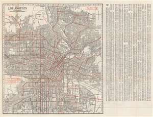
Map of Los Angeles California.
$350.00
Acquire
- Digital Map Information
- Suitable for large format printing
- Full resolution TIFF file
- ICC color profile embedded
- Delivered instantly via download link
This is a c. 1937 Ernest F. Hill city plan or map of Los Angeles, California, published during the Great Depression. Mass transit takes center stage, with red overprinting highlighting railway and bus routes, including those of the Pacific Electric Railway. A key situated on the left side informs the viewer that the L. A. Railway uses yellow cars and the Pacific Electric Railway ran red cars. Red overprinting labels suburbs as well, including Glendale, Belvedere Gardens, Vernon, Huntington Park, Inglewood, and Hollywood. Innumerable streets are correlated to an index printed at right. A map of the western portion of Los Angeles (complete with a street index) and a map of Long Beach appear on on the verso. (more details)
Los Angeles Just After World War II.
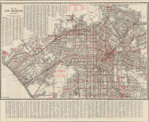
Map of Los Angeles California / Hill's Official City Map and Tourist Guide of Los Angeles Pasadena and San Gabriel Valley Addition.
$350.00
Acquire
- Digital Map Information
- Suitable for large format printing
- Full resolution TIFF file
- ICC color profile embedded
- Delivered instantly via download link
This is a 1946 Ernest F. Hill city plan or map of Los Angeles, California, and surrounding communities, published during a population boom in the wake of World War II (1939 - 1945). The war was a watershed event in the history of Southern California, with thousands of servicemen passing through the region and many settling there afterward. (more details)