
Instituto Geográfico Nacional

The Instituto Geográfico Nacional (IGN) (1870 - Present) is the national napping agency of Spain. Created on September 12, 1870, its name has changed several times throughout its history, including the Instituto Geográfico y Catastral and the Instituto Geográfico, Catastral y Estadístico, before being christened the Instituto Geográfico Nacional in 1977.
Spain and Portugal's railway networks in the mid-1950s.
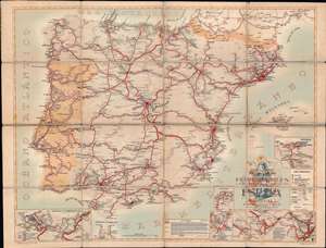
Mapa de los Ferrocarriles en Explotación Construcción y Proyecto en España y Portugal por Alfredo Forcano Catalán.
$950.00
Acquire
This is a striking 1956 Instituto Geográfico y Catastral map of Spain and Portugal and their national railroad networks. The Instituto Geográfico deftly employs color coding to differentiate between rail lines. The solid red lines, which dominate the map, illustrate the Spanish national railway network. Thin purple rail lines, which appear almost exclusively in the various insets situated around the border, are operated only by the Spanish government. Green and orange lines represent independent railroad companies. Importantly, wide gauge lines are illustrated by the wider lines, while the skinnier lines trace narrow gauge routes. Blank or white coding indicate railroads under construction. A key appears in the bottom right, with the leyendasignos conviencionales along the right border. (more details)