
Jylbert

Jylbert (fl. c. 1934 - c. 1956) (known only by this pseudonym) was an illustrator active in France during the mid-20th century. They illustrated an edition of Voltaire's masterpiece Candide published in 1934. During World War II (1939 - 1945), Jylbert created a series of at least 20 pictorial maps published in 1943 that were likely used to teach the French Empire to schoolchildren. They also illustrated an atlas of French provinces that was published in 1943. Per OCLC, Jylbert illustrated editions of many celebrated novels during the 1950s, including Moby Dick, The Three Musketeers, Gulliver's Travels, and Treasure Island.
French Guiana under the Vichy.
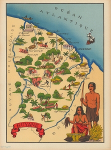
Guyane.
$200.00
Acquire
- Digital Map Information
- Suitable for large format printing
- File Size: 7.04 MB
- File Type: ZIP / TIFF
- ICC color profile embedded
- Delivered instantly via download link
This is a 1943 Jylbert pictorial map of French Guiana. This map was part of a series of 20 maps of the French Empire drawn by Jylbert during the Nazi occupation of France to educate French schoolchildren on the wonders of the Empire and foster national pride. Trees fill the colony and impart ideas of a tropical land. The famous penal colony is not included. (more details)
Gabon, published during WWII.
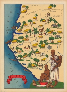
Gabon.
$200.00
Acquire
- Digital Map Information
- Suitable for large format printing
- File Size: 6.61 MB
- File Type: ZIP / TIFF
- ICC color profile embedded
- Delivered instantly via download link
This is an intriguing 1943 Jylbert pictorial map of Gabon and Equatorial Guinea. When this map was issued, France was occupied by Nazi Germany. As part of French Equatorial Africa, Gabon was opposed to the collaborationist Vichy Regime and allied with de Gaulle's Free French. (more details)