
LeSourd, Gilbert Quinn

Gilbert Quinn LeSourd (February 1, 1887 - June 22, 1962) was an American missionary, educator, reverend, and publisher active in New York and New Jersey in the early 20th century. LeSourd was born in Seattle, Washington. He received his early education at the College of Puget Sound, followed by and a bachelor of divinity from Drew Theological Seminary, an da doctorate of philosophy from New York University. LeSourd was the owner of Friendship Press, a printing house focused on missionary texts, maps, and other educational materials. He was also the Associate Secretary of the Missionary Education Movement. LeSourd died in Schenectady, New York.
Largest American pictorial map of China predating World War II.
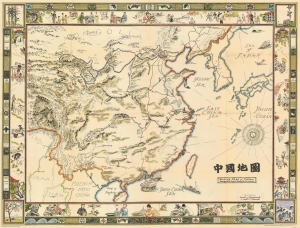
Picture Map of China. 中國地圖
$1,800.00
Acquire
- Digital Map Information
- Suitable for large format printing
- File Size: 88.9 MB
- File Type: ZIP / TIFF
- ICC color profile embedded
- Delivered instantly via download link
This is a striking full-color large-format 1932 pictorial wall map of China illustrated by Frank Randolph Southard. Presenting a romanticized view of China, this is the only large-format pictorial map of China to appear before World War II (1939 - 1945). Coverage embraces China as well as neighboring Korea and parts of Japan. It is surrounded by an elaborate decorative border featuring Chinese iconography as well as views of Chinese life. (more details)
Promotes the ideas of universal rights.
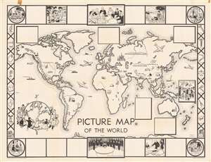
Picture Map of the World.
$550.00
Acquire
- Digital Map Information
- Suitable for large format printing
- Full resolution TIFF file
- ICC color profile embedded
- Delivered instantly via download link
This is a 1948 Janet Smalley and Jeanne McLavy pictorial map of the world. Icons placed across the world highlight historic landmarks, such as the Lincoln Memorial, Cristo Redentor in Rio de Janeiro, the Sphinx at Giza, the Acropolis in Athens, St. Basil's Cathedral in Moscow, and the Taj Mahal in Agra, India. Other icons illustrate trains, planes, and buses, moving the world's people from one place to another. Churches appear throughout the world as well, although many are not identifiable. Penguins appear along the bottom border. Five blank boxes are scattered around the map, likely meant to highlight cultural events worldwide, since one box contains an illustration of the Boy's Festival in Japan. (more details)