
Naoha Shūhei

Naoha Shūhei (猶葉周平; fl. c. 1878 - 1882), also publishing under Hiranoya (平野屋), the name (屋号) of his shop, was a Tokyo-based publisher. He was active for a handful of years and nothing is known about his biography, but Naoha appears to have had a connection with the authorities, as his published works include maps of Tokyo reflecting the frequent administrative reorganizations of the era as well as a ukiyo-e triptych depicting high-level Meiji officials (明治官員鑑), a clever, circular explanation of revised weights and measures (改正區分一覧), and at least two ukiyo-e triptychs reflecting cultural change and urban development in Tokyo (鳳凰輦御臨幸之圖 and 東京名所寿留賀町三ツ井店両側富嶽眺望之圖).
Transformation of Tokugawa Edo into a Imperial Tokyo.
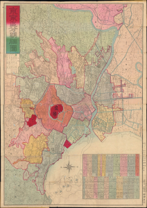
改正 東亰區分明細圖 / [Revised Detailed Map of Tokyo Divided into Wards].
$1,000.00
Acquire
- Digital Map Information
- Suitable for large format printing
- Full resolution TIFF file
- ICC color profile embedded
- Delivered instantly via download link
A striking 1880 Meiji-era city plan of Tokyo, Japan, by Naoha Shūhei, capturing the imperial capital as it transformed from Tokugawa Edo into a modern metropolis. Published shortly after the creation of Tokyo's 15 urban wards, the map combines traditional Japanese cartographic aesthetics with Western conventions, vividly documenting both the city's new administrative geography and its rapidly changing infrastructure. (more details)