
1880 Naoha Shuhei Plan or Map of Tokyo, Japan

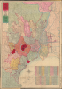
改正 東亰區分明細圖 / [Revised Detailed Map of Tokyo Divided into Wards].
Transformation of Tokugawa Edo into a Imperial Tokyo.
- Digital Map Information
- Suitable for large format printing
- Full resolution TIFF file
- ICC color profile embedded
- Delivered instantly via download link
Transformation of Tokugawa Edo into a Imperial Tokyo.
A striking 1880 Meiji-era city plan of Tokyo, Japan, by Naoha Shūhei, capturing the imperial capital as it transformed from Tokugawa Edo into a modern metropolis. Published shortly after the creation of Tokyo's 15 urban wards, the map combines traditional Japanese cartographic aesthetics with Western conventions, vividly documenting both the city's new administrative geography and its rapidly changing infrastructure.A Closer Look
The map is oriented with north at the top, somewhat unusually compared to most earlier maps of Edo/Tokyo, which more often place west at the top to be directed towards Mt. Fuji (even if the mountain is generally not on the map itself). This may reflect Western cartographic norms, as may also be the case with the inclusion of shoals in Tokyo Bay. The map's primary purpose is to display Tokyo's 15 wards, established by an 1878 law, which are color-shaded here for easy distinction. The wards and their constituent city blocks (丁) are labeled on the map, while a table at the bottom-right lists the same information along with statistics on the number of households and residents within the city and in its suburban / rural hinterland (counties outside of the 15 wards). Property of the imperial family, including the Imperial Palace (皇居) at the center, is shaded red. A legend below the title indicates symbols and lines used for railways, waterways, telegraph lines and offices, administrative boundaries, lighthouses, temples, shrines, and more. Tokyo's first railway and its station (Shimbashi, here as 停車場), opened in 1872, appear towards the bottom, with an illustrated train chugging towards Yokohama.Meiji Era Tokyo
With the Meiji Restoration in 1868, the Tokugawa Shogunate was displaced from Edo and the Emperor Meiji moved the imperial capital from Kyoto to Edo (renamed Tokyo, 'eastern capital'). The Meiji Era brought tremendous change to Japan, especially in cities, and in Tokyo more than anywhere else. New ideas, technologies, and fashions from abroad were sought out and adopted with incredible rapidity, and in the process were localized to suit Japanese tastes.Building on the foundations of Tokugawa Edo, Meiji-era Tokyo intermingled traditional architecture with styles reminiscent of Victorian London. Even the layout of the city was hybrid; here we can see Nihonbashi (日本橋) and Kyobashi (京橋), historically the most densely populated areas of Edo, as well as recent additions like Shimbashi Station, Tokyo's first railway station at left, and the industrialization of Fukagawa (深川) and Honjo (本所) Wards at bottom. Much of Tokyo as it exists here was destroyed in the 1923 Great Kanto Earthquake.
A Bustling Imperial Capital
Tokyo and several other Japanese cities underwent a dizzying period of administrative reforms during the Meiji era, driven by rapid growth and changing bureaucratic practices and conceptions of governance. Initially, officials maintained elements of the Tokugawa ward system to appease elites who feared faster reforms. Then, in 1871-72, Tokyo Prefecture was expanded, and a system of 'large and small wards' (大區小區制) was put into place. An 1878 law abolished these large and small wards and established a simpler system, with the 15 urban wards and six rural counties for Tokyo shown here. Further adjustments were made in the following years, and a wholesale reorganization was launched in 1888-89, when many of the wards (郡) shown here ceased to exist.The Height of Meiji Cartographic Art
Stylistically, this map represents the height of the Meiji-era (1868 - 1912) cartographic tradition - wherein western style cartographic standards, lithographic printing, and imported inks were combined with Ukiyo-e color traditions and aesthetic values. This map falls in a cartographic lineage that begins with the Meiji Restoration and continued through about 1895. Here, the boldly bright palette likely associates this map with aka-e (赤絵; 'red pictures'), illustrations in vivid color achieved through imported German-made inks. Such maps began to fall out of fashion near the turn of the century, when more reserved printed color supplanted them.Publication History and Census
This map is dated Meiji 13 (1880) and was edited and published by Naoha Shūhei of Hiranoya in Nihobashi. The cover (seen in the verso image here) calls it 'Revised' (改正), but by all appearances it is a first edition, with 'Revised' likely referring to recent administrative changes in Tokyo. Subsequent editions were published in 1881 and 1882, all are now scarce. The present first edition is held only in the institutional collections of the University of California, Berkeley, the National Diet Library, the Edo-Tokyo Museum, and the National Institute of Japanese Literature.Cartographer
Naoha Shūhei (猶葉周平; fl. c. 1878 - 1882), also publishing under Hiranoya (平野屋), the name (屋号) of his shop, was a Tokyo-based publisher. He was active for a handful of years and nothing is known about his biography, but Naoha appears to have had a connection with the authorities, as his published works include maps of Tokyo reflecting the frequent administrative reorganizations of the era as well as a ukiyo-e triptych depicting high-level Meiji officials (明治官員鑑), a clever, circular explanation of revised weights and measures (改正區分一覧), and at least two ukiyo-e triptychs reflecting cultural change and urban development in Tokyo (鳳凰輦御臨幸之圖 and 東京名所寿留賀町三ツ井店両側富嶽眺望之圖). Further Details...
Condition
Average. Wormholing throughout. Light wear along original fold lines. Attached to original binder.
References
OCLC 21808916, 676470010. Edo-Tokyo Museum Doc. No. 86213232. National Museum of Japanese Literature IA0077026.