
Peirce, Benjamin

Benjamin Peirce (April 4, 1809 - October 6, 1880) was a mathematician who taught at Harvard University for nearly 50 years. He served as director of the U.S. Coast Survey from 1867 to 1874. He made contributions to the fields of celestial mechanics, statistics, number theory, algebra, and the philosophy of mathematics. He was appointed professor of mathematics at Harvard in 1831, only two years after his graduation.
Detailed Early Coastal Chart of Edgartown Harbor

Section I, Edgartown Harbor and Cotamy Bay, Mass.
$750.00
Acquire
- Digital Map Information
- Suitable for large format printing
- File Size: 45.16 MB
- File Type: ZIP / TIFF
- ICC color profile embedded
- Delivered instantly via download link
A very rare 1871 U.S. Coast Survey Map of Edgartown and Katama Bay on Martha's Vineyard, Massachusetts. This detailed working harbor chart was produced to illustrate the buildup of sand in the bay (making it unnavigable) in order to argue for the opening of a safe passage through Katama Beach. The chart shows the approaches to Edgartown - both the main approach from the northeast, marked by a lighthouse, and also the approaches via Katama Bay (Cotamy on the map)- whose mouth is shown entirely blocked by Katama Beach. Historical natural openings in the beach are noted, including a 1776 opening which had appeared on Des Barres' chart of the island, are noted. Nine cross sections of the beach are shown, indicating the height of the beach above sea level. A further cross section, showing the increasing silt blockage of the northern mouth of the Bay between the west shore and Chappaquiddick Point is shown as well. Tidal patterns measured inside and outside Katana bay are compared in a chart. Detailed soundings are provided throughout. (more details)
Features Mount Desert Island and Passamaquoddy Bay!
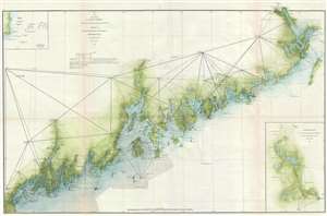
Sketch A Showing the Progress of the Survey in Section No. 1 from 1852 to 1871.
$1,200.00
Acquire
- Digital Map Information
- Suitable for large format printing
- File Size: 9.94 MB
- File Type: ZIP / TIFF
- ICC color profile embedded
- Delivered instantly via download link
This is an 1871 U.S. Coast Survey nautical chart or maritime map of the coast of Maine. The map depicts the region from Portland Maine to Passamaquoddy Bay and inland as far as Bangor and Calais. Intricately charted, myriad coastal islands are illustrated and ... (more details)