1886 U.S. Coast Survey Chart of Fox Islands, Knox County, Maine
FoxIslandsME-uscs-1886$450.00


Title
Fox Islands Thoroughfare Maine.
1886 (dated) 20 x 31.5 in (50.8 x 80.01 cm) 1 : 20000
1886 (dated) 20 x 31.5 in (50.8 x 80.01 cm) 1 : 20000
Description
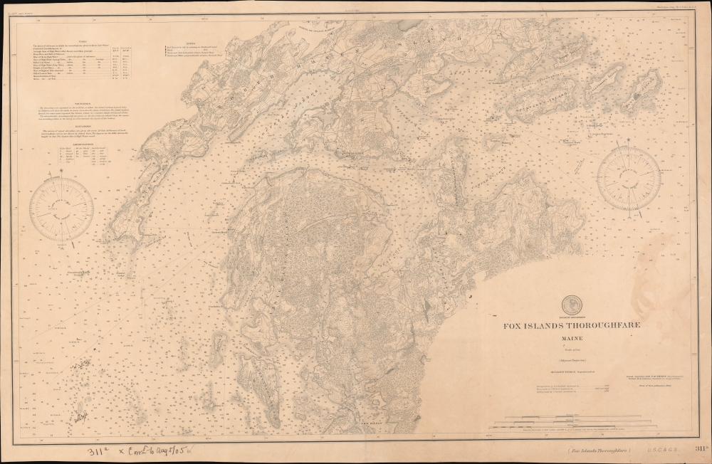
An 1886 nautical chart or map of the Fox Islands Thoroughfare between Vinalhaven and North Haven, Knox County, Maine, produced by the U.S. Coast Survey. In addition to providing a helpful guide for navigators, it demonstrates the increasing standardization and complexity of nautical charts in the second half of the 19th century.
Unlike the earliest issue of the map in 1868 (previously sold by us), the present edition fills in topography, roads, and other details on land. Other notable differences are evident from a comparison of the two charts, such as the addition of lighthouses and buoys established in the intervening years. Handwritten annotations at bottom-left provide updates or corrections to August 1905, indicating this chart's use aboard a ship.
A Closer Look
The thoroughfare is bounded by two large landmasses at top and bottom, the namesake Fox Islands, concurrent with the towns of North Haven and Vinalhaven. Soundings, shoals, rocks, variations, tides, lighthouses, and abbreviations for various features (explained at top-left) are noted throughout, exhibiting tremendous precision. Small red and/or black diamonds with circles underneath indicate buoys.Unlike the earliest issue of the map in 1868 (previously sold by us), the present edition fills in topography, roads, and other details on land. Other notable differences are evident from a comparison of the two charts, such as the addition of lighthouses and buoys established in the intervening years. Handwritten annotations at bottom-left provide updates or corrections to August 1905, indicating this chart's use aboard a ship.
Publication History and Census
This chart was originally produced by the U.S. Coast Survey in 1868 and was later reissued in 1879 and 1886. This edition is listed among the holdings of the University of Chicago, the Boston Public Library, and the British Library.CartographerS
The Office of the Coast Survey (1807 - present) founded in 1807 by President Thomas Jefferson and Secretary of Commerce Albert Gallatin, is the oldest scientific organization in the U.S. Federal Government. Jefferson created the "Survey of the Coast," as it was then called, in response to a need for accurate navigational charts of the new nation's coasts and harbors. The spirit of the Coast Survey was defined by its first two superintendents. The first superintendent of the Coast Survey was Swiss immigrant and West Point mathematics professor Ferdinand Hassler. Under the direction of Hassler, from 1816 to 1843, the ideological and scientific foundations for the Coast Survey were established. These included using the most advanced techniques and most sophisticated equipment as well as an unstinting attention to detail. Hassler devised a labor intensive triangulation system whereby the entire coast was divided into a series of enormous triangles. These were in turn subdivided into smaller triangulation units that were then individually surveyed. Employing this exacting technique on such a massive scale had never before been attempted. Consequently, Hassler and the Coast Survey under him developed a reputation for uncompromising dedication to the principles of accuracy and excellence. Unfortunately, despite being a masterful surveyor, Hassler was abrasive and politically unpopular, twice losing congressional funding for the Coast Survey. Nonetheless, Hassler led the Coast Survey until his death in 1843, at which time Alexander Dallas Bache, a great-grandson of Benjamin Franklin, took the helm. Bache was fully dedicated to the principles established by Hassler, but proved more politically astute and successfully lobbied Congress to liberally fund the endeavor. Under the leadership of A. D. Bache, the Coast Survey completed its most important work. Moreover, during his long tenure with the Coast Survey, from 1843 to 1865, Bache was a steadfast advocate of American science and navigation and in fact founded the American Academy of Sciences. Bache was succeeded by Benjamin Pierce who ran the Survey from 1867 to 1874. Pierce was in turn succeeded by Carlile Pollock Patterson who was Superintendent from 1874 to 1881. In 1878, under Patterson's superintendence, the U.S. Coast Survey was reorganized as the U.S. Coast and Geodetic Survey (C & GS) to accommodate topographic as well as nautical surveys. Today the Coast Survey is part of the National Oceanic and Atmospheric Administration or NOAA as the National Geodetic Survey. More by this mapmaker...
Benjamin Peirce (April 4, 1809 - October 6, 1880) was a mathematician who taught at Harvard University for nearly 50 years. He served as director of the U.S. Coast Survey from 1867 to 1874. He made contributions to the fields of celestial mechanics, statistics, number theory, algebra, and the philosophy of mathematics. He was appointed professor of mathematics at Harvard in 1831, only two years after his graduation. Learn More...
Frank Manly Thorn (December 7, 1836 - 1907) was an American businessman, politician, and lawyer who served as the sixth Superintendent of the Coast and Geodetic Survey who holds the distinction of being the first non-scientist to hold the position. Born in Erie County, New York, near Buffalo, Thorn attended local schools and then the Fredonia Academy in Fredonia, New York. After graduating, he returned to Erie County where he served as a clerk in Surrogate's Court, where his father, a trained lawyer, served as Surrogate Judge. Soon Thorn was enrolled in law school in Albany, New York and eventually became a licensed lawyer himself. This, however, was essentially the end of his legal career. Thorn moved to Pennsylvania in 1860, where he began work in the petroleum industry. In 1867, after the Civil War, he moved back to Erie County and started working in the legal profession, while at the some time establishing a successful fruit orchard and farm. He also began writing and publishing humorous sketches in local newspapers under pseudonyms and performing as an after-dinner speaker and humorist lecturer, ventures at which he apparently had some success. Thorn began his political career in 1870 when he was elected to the Erie County Board of Supervisors, a position he held until 1880. In 1882, Thorn joined Grover Cleveland's successful campaign for Governor of New York and two years later campaigned for Cleveland in his bid for the presidency. Cleveland won the 1884 Presidential Election, and, only a few months later, Cleveland named Thorn Superintendent of the Coast and Geodetic Survey. Thorn replaced Julius Hilgard, who had been forced to resign in disgrace after James Q. Chenowith and the Allison Commission found him to be a drunkard and unable to lead the Survey. In 1889, after Cleveland lost the 1888 Presidential Election, Thorn was replaced as Superintendent by Thomas C. Mendenhall. After leaving office, Thorn returned to his farm in Orchard Park, New York, where he resumed life as a gentleman farmer and public figure. Learn More...
Condition
Good. Even overall toning. Some discoloration along right border.
References
OCLC 1037498699, 557421594.