
Pham Thang

Phạm Thăng (fl. c. 1965 - 1967) was a Vietnamese mapmaker and graphic artist active in Saigon during the mid-1960s. There are several city plans and infographic maps from the Vietnam War Era attributed to this figure, although it remains unclear who he was. There is a well known artist by this name, however, it is uncertain if they are related in any way.
Vietnamese city plan of Saigon published during the Vietnam War.
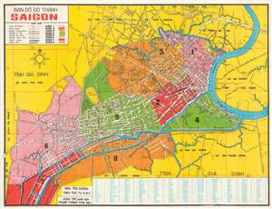
This is a 1966 Pham Thang city map or plan of Saigon, South Vietnam. The map depicts the city from the border between Saigon and An Lac to Gia Định Province and from Bình Hòa to Bình Hưng. Streets throughout are labeled in Vietnamese, along with parks and rivers, including the Saigon. The city's eight quận, or counties, are numerically identified and shaded different colors to allow for easy differentiation. Villages around the city are identified. An index of streets and other locations across the city is situated along the bottom border and provides the grid location where each place is located. (more details)