
Pham Thang (sold)

Phạm Thăng (fl. c. 1965 - 1967) was a Vietnamese mapmaker and graphic artist active in Saigon during the mid-1960s. There are several city plans and infographic maps from the Vietnam War Era attributed to this figure, although it remains unclear who he was. There is a well known artist by this name, however, it is uncertain if they are related in any way.
A Vietnamese map of North Vietnam published during the Vietnam War.
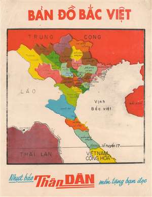
This is a c. 1965 Phạm Thăng Vietnamese map of North Vietnam, published Vietnam during the Vietnam War (1955 - 1975). Created by the South Vietnamese cartographer, Phạm Thăng, the map illustrates Communist North Vietnam from the border with China to the border with South Vietnam (17° N). North Vietnamese provinces are color coded and labeled, with the provincial capital named in each. The 17th parallel separates North and South Vietnam. South Vietnam is labeled merely as Cộng Hòa, which translates to 'Republic.' (more details)
A South Vietnamese map highlighting part of Operation Rolling Thunder, the largest aerial campaign of the Cold War.
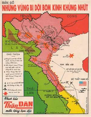
Bản Đồ Những Vũng Bị Dội Bom Kinh Khủng Nhứt. [Map of the Bombed Area].
sold
- Digital Map Information
- Suitable for large format printing
- File Size: 8.57 MB
- File Type: ZIP / TIFF
- ICC color profile embedded
- Delivered instantly via download link
This is a 1965 Phạm Thăng infographic map of bombarded areas in North Vietnam. The map depicts the region from China to Da Nang in South Vietnam and from Thailand to Hainan Province in China. Aerial bombing campaigns undertaken by the forces of the Army of the Republic of Vietnam (ARVN) and the United States are highlighted by red bomb bursts. The entire area from Vinh Linh near the border between North and South Vietnam north to Thanh Hoa is surrounded by this bomb burst imagery and a caption states that the region was intensely bombed. Other targeted areas include Bach Long Vi Island in the Gulf of Tonkin, which was bombed once. However, airstrikes were forbidden within sixty kilometers of Hanoi and nineteen kilometers of Haiphong, which are illustrated by concentric circles. Surface-to-air missile (SAM) emplacements in the region are illustrated by the triangles and the small plane near Hanoi symbolizes an airbase equipped with MiG-III aircraft. The ships illustrated off the coast of South Vietnam is the U.S. Seventh Fleet. The Ho Chi Minh Trail, North Vietnam's famous supply route for men and supplies into South Vietnam is also illustrated. (more details)
A Vietnamese map of the Ho Chi Minh Trail, the critical supply route between North Vietnam and South Vietnam, and also the site of the most intense bombing campaign in human history.
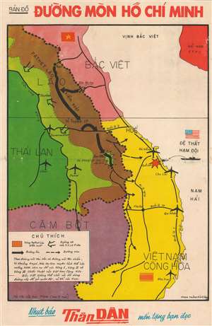
Bản Đồ Đường Mòn Hố Chí Minh. [Ho Chi Minh Trail Map].
sold
- Digital Map Information
- Suitable for large format printing
- File Size: 15.99 MB
- File Type: ZIP / TIFF
- ICC color profile embedded
- Delivered instantly via download link
This is a 1965 Phạm Thăng map of the Ho Chi Minh Trail during the Vietnam War. The map depicts the region from Thailand and Cambodia to the South China Sea and from North Vietnam and Hainan, China to Nha Trang in South Vietnam. Originally published in TIME Magazine, the Ho Chi Minh Trail, illustrated here by thick black arrows, connected North Vietnam and South Vietnam via Laos and Cambodia, allowing the North Vietnamese to ferry troops and supplies into South Vietnam while circumventing the demilitarized zone along the 17th parallel. North Vietnam is colored red here, not surprising since red is a color associated with communism, and South Vietnam is shaded yellow. U.S. air bases at Da Nang, Chu Lai, Qui Nhon, and Nha Trang are marked by airplanes, while an attack at Khe Sanh by the U.S. Seventh Fleet is highlighted by a red explosion.
Outside of Vietnam, Laos is split between light green, territory held by the Royal Lao Government, and brown, the area controlled by the Pathet Lao, a communist political movement that was ultimately victorious in the Laotian Civil War, which raged from 1959 - 1975. The Ho Chi Minh Trail passed through Pathet Lao territory, while the CIA maintained a base at Pakse. Thailand is shaded dark green, while Cambodia is a dark purple. Ubon Royal Thai Air Force Base, one of the bases used by the U.S. Air Force throughout the Vietnam War, is labeled. About 80% of all U.S. Air Force operations against North Vietnam during the Vietnam War originated in Thailand (more details)
Outside of Vietnam, Laos is split between light green, territory held by the Royal Lao Government, and brown, the area controlled by the Pathet Lao, a communist political movement that was ultimately victorious in the Laotian Civil War, which raged from 1959 - 1975. The Ho Chi Minh Trail passed through Pathet Lao territory, while the CIA maintained a base at Pakse. Thailand is shaded dark green, while Cambodia is a dark purple. Ubon Royal Thai Air Force Base, one of the bases used by the U.S. Air Force throughout the Vietnam War, is labeled. About 80% of all U.S. Air Force operations against North Vietnam during the Vietnam War originated in Thailand (more details)
A Vietnamese city plan of Saigon published during the Vietnam War.
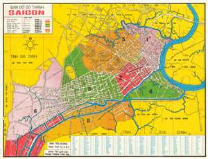
Bản Đồ Đô Thành Saigon. [Map of the City of Saigon].
sold
- Digital Map Information
- Suitable for large format printing
- File Size: 36.19 MB
- File Type: ZIP / TIFF
- ICC color profile embedded
- Delivered instantly via download link
This is a 1966 Pham Thang city map or plan of Saigon, South Vietnam. The map depicts the city from the border between Saigon and An Lac to Gia Định Province and from Bình Hòa to Bình Hưng. Streets throughout the city are labeled in Vietnamese, along with parks and rivers, including the Saigon. The city's eight quận, or counties, are numerically identified and shaded different colors to allow for easy differentiation. Villages around the city are identified. An index of streets and other locations across the city is situated along the bottom border and provides the grid location where each place is located. (more details)