1956 Robertson Diazotype Map of Nevada Placer Gold Deposits
NevadaGoldPlacer-robertson-1956$450.00

Title
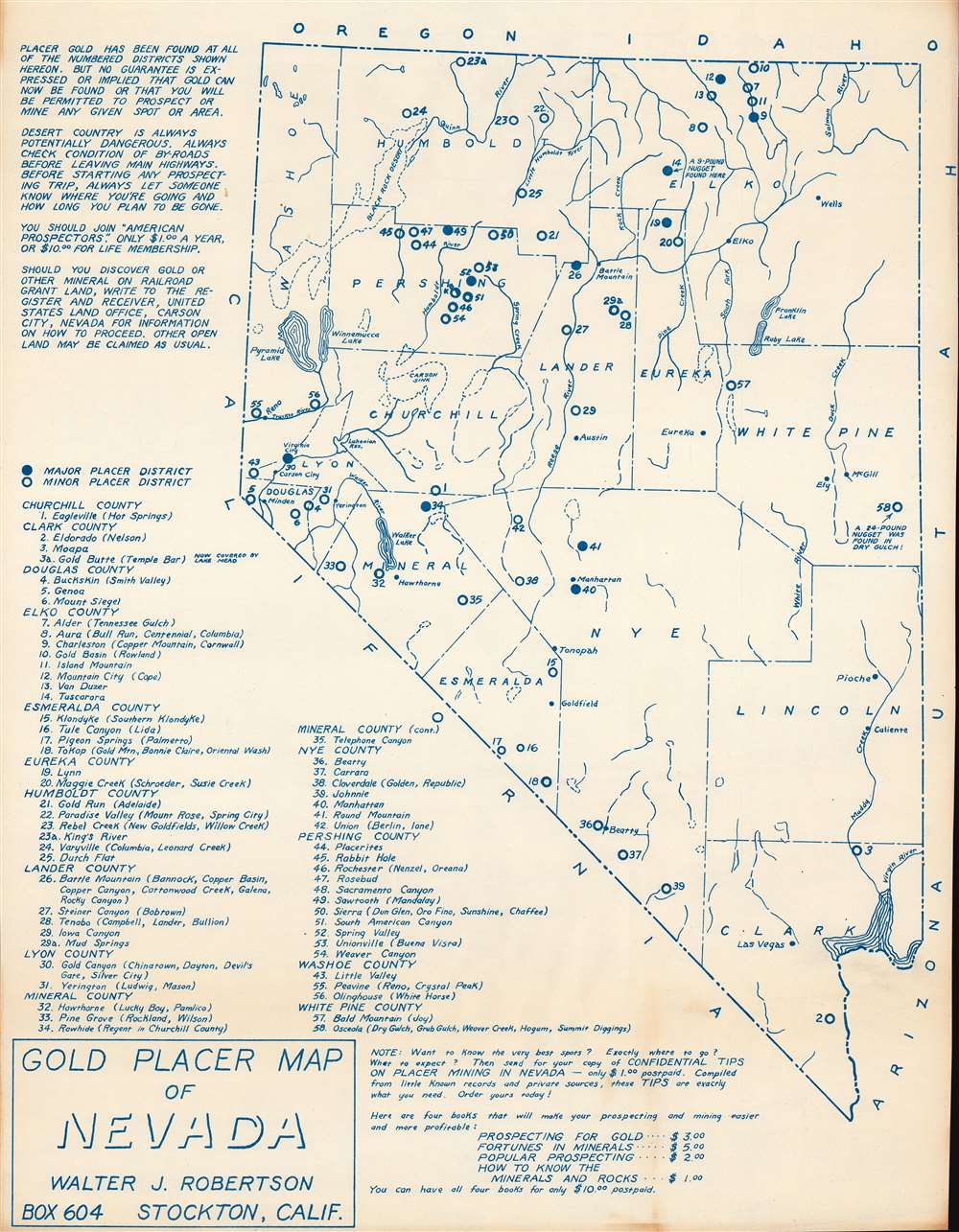
Gold Placer Map of Nevada.
1956 (undated) 21.5 x 16.75 in (54.61 x 42.545 cm) 1 : 1650000
1956 (undated) 21.5 x 16.75 in (54.61 x 42.545 cm) 1 : 1650000
Description
This is a c. 1956 Walter J. Robertson diazotype map of Nevada's placer gold deposits. Fifty-eight locations where placer gold was discovered are numerically identified throughout and correspond with an index in the lower-left. Some deposits are embellished with short comments. Among these are Site 58, which includes the caption 'a 24-pound nugget was found in Dry Gulch!', and Site 14, which notes that 'a 9-pound nugget found here'. Robertson includes a note about other gold mining and prospecting literature he has for sale along the bottom border, including four books about gold prospecting, such as 'Confidential Tips on Placer Mining in Nevada'.
Gold Mining in Nevada
Gold was first discovered in Nevada in the 1870s but very little was excavated. In 1907, placer gold deposits were discovered, but were not sufficiently rich to drive much excitement. In 1961, the Carlin Trend, a low-grade gold deposit five miles wide by forty miles long, was discovered by the Newmont Mining Corporation. By 2002, over 50,000,000 troy ounces of gold had been extracted from the Trend, meaning that it has produced more gold than any other mining district in the United States. Nevada produced seventy-eight percent of gold in the United States in 2018, which accounted for five percent of global production. Nevada remains one of the largest sources of gold in the world today.Diazo Print or Whiteprint
The diazo print (whiteprint or diazo for short) is a photo reproductive technique best understood as a reverse cyanotype or blueprint. The process yields distinctive blue lines on white paper. Like cyanotypes, the diazo process gained popularity in architecture circles, where it was a simple and effective way to duplicate documents in the field. The earliest diazotypes appeared around 1880 and were adopted for military and field cartographic use from about 1895. The diazo process was commercialized in 1923, when the German firm, Kalle and Company, developed Ozalid, a patented diazo paper that made diazotyping even easier. By the 1950s, it supplemented cyanotypes as the reprographic technique of choice for technical drawings.Publication History and Census
This map was created and published by Walter J. Robertson c. 1956. This is the only known cataloged example.Cartographer
Walter James Robertson (October 2, 1910 - May 9, 1978) was an American publisher and cartographer. Born in Colorado, Robertson lived most of this life in Stockton, California. Beginning in the 1950s (or possibly earlier), Robertson began publishing materials dealing with mining, including a pamphlet titled 'Gold Panning for Profit'. He also published a series of placer mining maps of several western states, including Oregon, Arizona, and Northern and Southern California. More by this mapmaker...
Condition
Very good. Cyanotype.