1956 Robertson Diazotype Map of Arizona Placer Gold Deposits
ArizonaGoldPlacer-robertson-1956$325.00

Title
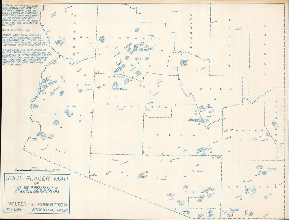
Gold Placer Map of Arizona.
1956 (undated) 16.5 x 21.75 in (41.91 x 55.245 cm) 1 : 1000000
1956 (undated) 16.5 x 21.75 in (41.91 x 55.245 cm) 1 : 1000000
Description
This is a c. 1956 Walter J. Robertson diazotype map of Arizona placer gold deposits. Circular areas of dots mark placer deposits, some of which are annotated with the value of nuggets discovered. Capital 'G's mark known lodes (which require underground mining and are much less likely to be attractive to prospectors). Although the Arizona gold rushes predate this map by decades, or even a century, prospectors continued to explore to this day. Robertson created this map, along with maps of other states where there were placer gold deposits, for those individuals.
Gold Mining in Arizona
Arizona's first gold rush began in 1858, but prospectors, explorers, and conquistadors had been searching for gold in Arizona long before. Hundreds of years earlier Spanish conquistadors searched throughout what became Arizona for mythical lost cities of gold. Even before that, Native Americans had been benefiting from Arizona's natural bounty, including turquoise, cinnabar, and other minerals. Gold mining operations continued throughout the 19th and 20th centuries, with the last operational gold mine shutting down in 1998. Even today, hopeful prospectors see potential in Arizona.Diazo Print or Whiteprint
The diazo print (whiteprint or diazo for short) is a photo reproductive technique best understood as a reverse cyanotype or blueprint. The process yields distinctive blue lines on white paper. Like cyanotypes, the diazo process gained popularity in architecture circles, where it was a simple and effective way to duplicate documents in the field. The earliest diazotypes appeared around 1880 and were adopted for military and field cartographic use from about 1895. The diazo process was commercialized in 1923, when the German firm, Kalle and Company, developed Ozalid, a patented diazo paper that made diazotyping even easier. By the 1950s, it supplemented cyanotypes as the reprographic technique of choice for technical drawings.Publication History and Census
This map was created and published by Walter J. Robertson c. 1956. We note a single cataloged example in OCLC which is part of the collection at the University of Wyoming. We have encountered one other instance when this map has appeared on the private market.Cartographer
Walter James Robertson (October 2, 1910 - May 9, 1978) was an American publisher and cartographer. Born in Colorado, Robertson lived most of this life in Stockton, California. Beginning in the 1950s (or possibly earlier), Robertson began publishing materials dealing with mining, including a pamphlet titled 'Gold Panning for Profit'. He also published a series of placer mining maps of several western states, including Oregon, Arizona, and Northern and Southern California. More by this mapmaker...
Condition
Very good.
References
OCLC 49230354.