This item has been sold, but you can get on the Waitlist to be notified if another example becomes available, or purchase a digital scan.
1610 Gioseppe Rosaccio Map of the World
World-rosaccio-1610$3,000.00

Title
Universale Descrittione di Tutto Il Mondo Del Eccte. Gioseppe Rosaccio.
1610 (undated) 10.25 x 12.25 in (26.035 x 31.115 cm)
1610 (undated) 10.25 x 12.25 in (26.035 x 31.115 cm)
Description
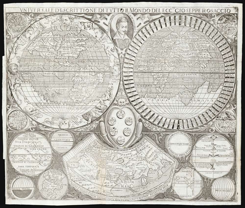
This is a rare c. 1610 map of the world, engraved by Luigi Rosaccio for inclusion in his father Giuseppe Rosaccio's final geographical text. This being the only map to accompany the work, it was tasked with conveying a broad array of concepts. Thus, the attractive engraving contains two main maps, eight diagrams, and four vignettes in addition to the decorative and dedicatory elements of the work.
The circumference of each hemisphere is data-rich. The Eastern Hemisphere is surrounded with a spiraling banner motif labeling, on the left, the Ptolemaic climatic zones and on the right, the hours of the longest day at each latitude. The western hemisphere is decorated with a combination of zodiacal signs, and wind-heads. The three southern winds (Garbino, Mezzogiorno, and Sirocco) are depicted as fearsome death-heads, an allusion to the assumption that the southern winds carried plague.
The interstices of the primary map are decorated with fruitful vines. At the corners, four medallions depict the elements (Earth, Air, Fire and Water). At the central cusp of the hemispheres are a dedicatory portrait of Cosimo II de Medici (more on this later) and the Medici coat of arms - fancifully using the six balls to depict the six parts of the world (Africa, Europe, Asia, America, and the yet-undiscovered lands of the North and the South poles.) The portrait of Cosimo II - the young Grand Duke of Tuscany - indicates the state of the map, of which there are two knowns. The first state shows Cosimo without beard or moustache; the second state (of which our example is representative) includes what can only be described as hastily applied facial hair. Judging by contemporary paintings of the young man, he seems to have had difficulty producing a beard. Its absence on the first iteration of this map may well have offended the Duke, thus necessitating the swift facial edit. (Shirley, in his description of this map, describes Cosimo's portrait as 'dyspeptic' and we cannot say he was wrong.)
The Primary Map
Although Shirley describes this map as having been derived from Rosaccio's 1598 Orbis Terrae Compendiosa Descriptio, the two maps are very dissimilar in their projections and in many of their geographical details. The dramatic distortions of Africa and South America evident on the 1598 map are not repeated here, for example. The geography of Southeast Asia in general is superficially cruder than the earlier map, but the delineation of Japan (which on the 1598 map was of the already-outmoded 'kite' shape) is much closer to the version of Japan appearing on the 1595 Ortelius/Texeira map. As with the earlier Rosaccio, the southern part of the globe is dominated by a massive Terra Incognita. The north pole is populated with an indeterminate array of islands rather than a strict representation of Mercator's arctic quartet of landmasses.The circumference of each hemisphere is data-rich. The Eastern Hemisphere is surrounded with a spiraling banner motif labeling, on the left, the Ptolemaic climatic zones and on the right, the hours of the longest day at each latitude. The western hemisphere is decorated with a combination of zodiacal signs, and wind-heads. The three southern winds (Garbino, Mezzogiorno, and Sirocco) are depicted as fearsome death-heads, an allusion to the assumption that the southern winds carried plague.
The interstices of the primary map are decorated with fruitful vines. At the corners, four medallions depict the elements (Earth, Air, Fire and Water). At the central cusp of the hemispheres are a dedicatory portrait of Cosimo II de Medici (more on this later) and the Medici coat of arms - fancifully using the six balls to depict the six parts of the world (Africa, Europe, Asia, America, and the yet-undiscovered lands of the North and the South poles.) The portrait of Cosimo II - the young Grand Duke of Tuscany - indicates the state of the map, of which there are two knowns. The first state shows Cosimo without beard or moustache; the second state (of which our example is representative) includes what can only be described as hastily applied facial hair. Judging by contemporary paintings of the young man, he seems to have had difficulty producing a beard. Its absence on the first iteration of this map may well have offended the Duke, thus necessitating the swift facial edit. (Shirley, in his description of this map, describes Cosimo's portrait as 'dyspeptic' and we cannot say he was wrong.)
The Ancient World
Most sixteenth-century geographies built on the work of the second-century Alexandrian geographer Claudius Ptolemy, and it is not uncommon for them to include at least his map of the explored world. That map appears here, at the bottom-center of the engraving. It portrays the three parts of the world known to Ptolemy's era - Europe, Asia, and Africa. It depicts no further than 63 degrees north; the eastern limits of Asia do not appear. The Indian Ocean appears as an inland sea, bounded by an unexplored land connecting between Africa and China. This juxtaposition of ancient versus modern geography implicitly evoked the achievements of modern explorers.A Visual Geographical Glossary
The eight diagrams flanking the Ptolemaic map illustrate in condensed, economical form an array of basic geographical terms such as meridians, parallels, and horizons. A particularly clever 'map' illustrates the visual language used by mapmakers in their work by showing and naming islands, peninsulas, seas, capes, and so forth. One fascinating diagram uses human figures on a stylized globe to illustrate the differences between shadows cast at different latitudes.Rosaccio's Discorso
Rosaccio's book - his last - was a broad introduction to geography, bringing the reader a relatively state-of-the-art knowledge of the American discoveries. These included a detailed reference to Sir Francis Drake's circumnavigation of 1577 - 1580, as well as that Thomas Cavendish made in 1586 - 1588. (It is perhaps odd, then, that the map does not include Drake's revelation of the insularity of Tierra del Fuego.) The work was dedicated to the young Grand Duke of Tuscany, Cosimo II de Medici (May 12,1590 - February 28, 1621), best known as the patron of Galileo Galilei, his childhood tutor.Publication History and Census
The map was engraved by Aloisius Rosaccio, for inclusion in the 1610 Discorso di Gioseppe Rosaccio, published in Florence by Volcmar Tedesco. Only two examples are listed in institutional collections: the Osher Library has an example of this second state, which they date 1610. The Bayerische Staatsbibliothek lists an example but do not identify the state: they include an erroneous date of 1667.Cartographer
Giuseppe Rosaccio (approx. 1530 - 1620) was a Venetian physician, astrologer, and geographer. He was born in the Venetian city of Pordenone, and graduated from the University of Padua having studied philosophy, medicine and law. He moved to seek his fortune in Tricesimo, where he worked as a physician and may have taught literature. His legal education led him to serve as a judge there in civil trials during the period between 1561 and 1575. 1607 found him in Florence in the service of Grand Duke Cosimo II (patron of Galileo). Rosaccio married, and had at least two children: Leonardo - who died on April 30, 1603 - and Luigi (also rendered as Alouisio), who collaborated with his father in his geographical work.
He was a prolific author, producing as many as forty works disseminating new knowledge (to a lay audience, using the Italian vernacular). These were mostly on the topics of astronomy and his primary interest, geography. He ventured afield on an array of subjects, including essays on Islam. He remains best known for his geographical texts, which were popular and republished in multiple editions. These included a 1598 edition of Ptolemy, a 1607 geography of Italy, and his final work - the 1610 Discorso nel quale si tratta brevemente della nobiltà, et eccellenza della Terra rispetto à Cieli, et altri elementi, was dedicated to Cosimo II and contained novel information on the American continent, including Drake and Cavendish' circumnavigations. This work included a map drawn by his son Alouisio. More by this mapmaker...
Source
Rosaccio, G., Discorso nel quale si tratta brevemente della nobiltà, et eccellenza della Terra rispetto à Cieli, et altri elementi, (Florence) 1610.
Condition
Very good. Mended split along one fold, with no loss. Mend at insertion point on left, with small area of manuscript reinstatement of border.
References
OCLC 878560041. Shirley, Rodney W., The Mapping of the World: Early Printed World Maps 1472-1700, 268 state 2.