1561 / 1599 Ruscelli / Rosaccio Double-Hemisphere Map of the World
World-ruscelli-1598-2$1,750.00


Title
Orbis Descriptio.
1598 (undated) 6.25 x 10 in (15.875 x 25.4 cm) 1 : 160000000
1598 (undated) 6.25 x 10 in (15.875 x 25.4 cm) 1 : 160000000
Description
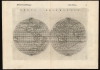
This is a 1598 second-state issue of Girolamo Ruscelli's 1561 map of the world. In its first 1561 state, it was the earliest acquirable double-hemisphere world map, but even this later issue remains one of the earliest acquirable maps to use this format.
A Closer Look
Like most maps in Ruscelli's Ptolemy, the geographic details were based on Giacomo Gastaldi's (1500 - 1566) 1548 Ptolemy. Here, the double-hemispherical projection transforms this map into a fully new composition. Amongst printed maps, it is predated only by the unacquirable 1555 Georgio Sideri Calapoda (fl. 1537 - 1565) map. The 1598 edition of Ruscelli's Ptolemy was edited by Giuseppe Rosaccio, who updated the maps to make them more competitive. In this case, there are significant geographical changes, most notably the addition of a massive southern continent - Terre Australis.The Map
The map is oriented to the north, with the three parts of the Old World in the right hemisphere and the fourth part of the world - the Americas - dominating the left. Some geographical elements are derived from Gastaldi's 1546 and 1548 world maps, but overall, this map diverges from any prior source. As with Gastaldi's maps through 1561, Ruscelli's map shows a clear connection between the continents of Asia and North America. Ruscelli adds a distinctive river system extending from the Gulf of California into the continent and includes abundant imaginary mountain ranges in North America.New Shores
Ruscelli's 1561 issue of the map implied the connection of North America and Asia, using broken lines to indicate unexplored or speculative territory - this was also the case with the southwest coast of South America. These coasts still bear the notations Littus incognitum and Littus ignotum, but the American Pacific Northwest is no longer ghosted, and there is an upturn in the coastline to suggest that it did not continue around to connect with Asia. The southern coasts of Tierra del Fuego and Java are no longer incomplete: Java is shown as a definite island, while Tierra del Fuego is connected to the southern continent, Terre Australis, after Mercator and Ortelius. The northern promontory of this territory, in the vicinity of Java (roughly in the location of Northern Australia), bears the place name Lucach, also influenced by the same mapmakers.An Island Northeast
Ruscelli may have derived his remarkable insular northeast America from the conflation of the Hudson River and the Saint Lawrence appearing on the Gastaldi-Ramusio map. Still, these features do not appear on any of Gastaldi's printed world maps. The bay separating the American Northeast from Terra Florida may have been influenced by the Sea of Verrazano, which appears prominently on Gastaldi's Carta Marina but not his other 1548 world map. This feature remains unchanged on this 1598 edition.South America
The overall shape of South America, including the mouth of the Rio de la Plata, is similar to the c. 1561 Gastaldi but differs from his earlier works and is very distinctive in its broad and angular shape.The North Part of the World
Ruscelli's depiction of the Arctic is distinctive: North America extends over the Pole and bears the place name Hyperborei - a classical geographical term originally applied to northern Eurasia, and later to northern Asia. Its presence here emphasizes Ruscelli's connection of Asia and North America. A Mare Glaciale covers the rest of the north. This feature appears unique to the Ruscelli, as neither Gastaldi's maps nor any other contemporary works show the Arctic in this way.Africa
The delineation of Africa, including the scattering of islands north of Madagascar, is roughly consistent with Gastaldi's geography. It preserves the Ptolemaic sourcing of the Nile and illustrates a large Senegal River with many tributaries. Madagascar itself is accurately shaped, though without interior detail. It is named only with the initials - 'S.L.' (San Lorenzo, an early term for the island).Southeast Asia
South Asia is mostly recognizable. The Indian peninsula, though narrow, resembles modern (as opposed to Ptolemaic) geography. Sri Lanka is marked with a 'Z,' indicating that it is being identified as Zeylon (Ceylon), as opposed to Taprobana, which we see contracted into 'Tapr.' and applied to Sumatra. Borneo also appears and is initialed 'Bor.' Java has an indeterminate coast, and the island north of Borneo (roughly corresponding to the Philippines) shows a similarly tentative northern shore. Japan is identified with the initials' IA' ('Iaponiae' after Ortelius). New Guinea, an archipelago on the 1561 map, follows Ortelius.Publication History and Census
This map was engraved for the 1561 first Ruscelli edition of Claudius Ptolemy's La Geografia di Claudio Tolomeo. In 1598, this work was edited and republished by Giuseppe Rosaccio. A further edition with minor typographical differences appeared in the 1599 edition. While only one separate example is listed in OCLC (National Library of Australia), the map occasionally appears on the market, and the volume is reasonably well represented in institutional collections.CartographerS
Girolamo Ruscelli (1500 - 1566) was an Italian polymath, humanist, editor, and cartographer active in Venice during the early 16th century. Born in Viterbo, Ruscelli lived in Aquileia, Padua, Rome and Naples before relocating to Venice, where he spent much of his life. Cartographically, Ruscelli is best known for his important revision of Ptolemy's Geographia, which was published posthumously in 1574. Ruscelli, basing his work on Gastaldi's 1548 expansion of Ptolemy, added some 37 new "Ptolemaic" maps to his Italian translation of the Geographia. Ruscelli is also listed as the editor to such important works as Boccaccio's Decameron, Petrarch's verse, Ariosto's Orlando Furioso, and various other works. In addition to his well-known cartographic work many scholars associate Ruscelli with Alexius Pedemontanus, author of the popular De' Secreti del R. D. Alessio Piemontese. This well-known work, or "Book of Secrets" was a compilation of scientific and quasi-scientific medical recipes, household advice, and technical commentary on a range of topics that included metallurgy, alchemy, dyeing, perfume making. Ruscelli, as Alexius, founded a "Academy of Secrets," a group of noblemen and humanists dedicated to unearthing "forbidden" scientific knowledge. This was the first known experimental scientific society and was later imitated by a number of other groups throughout Europe, including the Accademia dei Secreti of Naples. More by this mapmaker...
Giacomo Gastaldi (c. 1500 - October, 1566) was an Italian astronomer, cartographer, and engineer active in the second half of the 16th century. Gastaldi (sometimes referred to as Jacopo or Iacobo) began his career as an engineer, serving the Venetian Republic in that capacity until the fourth decade of the sixteenth century. During this time he traveled extensively, building a large library relating to voyages and exploration. From about 1544 he turned his attention to mapmaking, working extensively with Gextantiovanni Battista Ramusio, Nicolo Bascarini, and Giovanbattista Pedrezano, as well as taking private commissions for, among others, Venice's Council of Ten. He is credited with the fresco maps of Asia and Africa still extant in the map room of the Doge's Palace. Gastaldi was also one of the first cartographers to embrace copper plate over woodblock engraving, marking an important development in the history of cartography. His 1548 edition of Ptolemy's Geographia was the first to be printed in a vernacular; it was the first to be printed in copperplate. As with his Swiss/German contemporary Münster, Gastaldi's work contained many maps depicting newly discovered regions for the first time, including the first map to focus on the East Coast of North America, and the first modern map of the Indian Peninsula. His works provided the source for the vast majority of the Venetian and Roman map publishers of the 1560s and 70s, and would continue to provide an outsize influence on the early maps of Ortelius, De Jode, and Mercator. Learn More...
Giuseppe Rosaccio (approx. 1530 - 1620) was a Venetian physician, astrologer, and geographer. He was born in the Venetian city of Pordenone, and graduated from the University of Padua having studied philosophy, medicine and law. He moved to seek his fortune in Tricesimo, where he worked as a physician and may have taught literature. His legal education led him to serve as a judge there in civil trials during the period between 1561 and 1575. 1607 found him in Florence in the service of Grand Duke Cosimo II (patron of Galileo). Rosaccio married, and had at least two children: Leonardo - who died on April 30, 1603 - and Luigi (also rendered as Alouisio), who collaborated with his father in his geographical work.
He was a prolific author, producing as many as forty works disseminating new knowledge (to a lay audience, using the Italian vernacular). These were mostly on the topics of astronomy and his primary interest, geography. He ventured afield on an array of subjects, including essays on Islam. He remains best known for his geographical texts, which were popular and republished in multiple editions. These included a 1598 edition of Ptolemy, a 1607 geography of Italy, and his final work - the 1610 Discorso nel quale si tratta brevemente della nobiltà, et eccellenza della Terra rispetto à Cieli, et altri elementi, was dedicated to Cosimo II and contained novel information on the American continent, including Drake and Cavendish' circumnavigations. This work included a map drawn by his son Alouisio. Learn More...
Source
Ruscelli, G., La Geografia di Claudio Tolomeo Alessandrino…, (Venice: Heredi di Melchoir Sessa) 1599.
Beginning in 1561, Girolamo Ruscelli published this important, expanded edition of Giacomo Gastaldi's 1548 Ptolemy. Its maps, engraved in Venice by Giulio Sanuto, were in the main based directly upon those in Gastaldi's 1548 work. The maps were larger format than Gastaldi's, however, and Sanuto's engraving was far clearer and more legible than those appearing in the 1548 work. There are some important additions that distinguish Ruscell's Ptolemy from Gastaldi's. Ruscelli's work contained a map of the habitable world according to Ptolemy, which the Gastaldi lacked; also, the double-hemisphere map appearing in the Ruscelli was new and did not appear in the Gastaldi. Ruscelli's modern map of England was based on the work of George Lily, rather than the Waldseemüller-derived map appearing in the Gastaldi; the Ruscelli is the earliest generally acquirable map of England based on knowledge from someone who lived there. In a fateful innovation, Ruscelli's work included Septentrionalium partium nova tabula,the first copy of Nicolo Zeno's 1558 fraud Carta da Navegar, which introduced a novel mapping of the north parts of the world, including the phantom islands of Frisland, Icaria, Drogeo and Estotiland. Had Ruscelli not copied the Zeno - which had a narrow, brief publication - this preposterous geography would have probably not taken hold. Its inclusion in Ruscelli's beautiful, authoritative and popular work would lead to the adoption of the Zeno map by Mercator, Ortelius, Plancius and their successors, baffling scholars for centuries. Ruscelli's Ptolemy had a long publication history, cementing the influence of the work. It appeared both in Italian and Latin editions, all printed in Venice, throughout the latter 16th century:
- 1561 La Geographia di Claudio Tolomeo Alessandrino, Italian. Venice, Vincenzo Valgrisi.
- 1562 Geographia Cl. Ptolemaei Alexandrini, Latin. Venice, Vincenzo Valgrisi.
- 1564 La Geographia di Claudio Tolomeo Alessandrino, Italian. Venice, Giordano Ziletti.
- 1564 Geographia Cl. Ptolemaei Alexandrini, Latin. Venice, Giordano Ziletti.
- 1574 La Geographia di Claudio Tolomeo Alessandrino, Italian. Venice, Giordano Ziletti.
- 1598 Geographia di Claudio Tolomeo Alessandrino, Italian. Venice, heirs of Melchoir Sessa.
- 1599 Geographia di Claudio Tolomeo Alessandrino, Italian. Venice, heirs of Melchoir Sessa.
Condition
Very good. Mended wormholes at bottom centerfold and in mountain area of South America; else a bold example with generous margins.
References
Rumsey 11299.035 (1599 issue). OCLC 220034067. Shirley, Rodney W., The Mapping of the World: Early Printed World Maps 1472-1700, 110 state 2.