
Schley, Jacob van der (Jacobus van der Schley, Jakob van der Schley, Jacob van Schley)

Jacob van der Schley (July 26, 1715 - February 12, 1779) was a Dutch engraver and draftsman based in Amsterdam whose work for the 18th-century book trade included a substantial body of maps, coastal charts, town plans, and topographical views. Born in Amsterdam, he studied from about the age of twelve under Bernard Picart (1673 - 1733), whose engraving style he subsequently imitated, and completed unfinished plates after his master's death. His principal cartographic contribution was to the Hague editions of Antoine François Prévost's (1697 - 1763) Histoire générale des voyages and its Dutch counterpart, Historische beschryving der reizen, published by Pieter de Hondt (1696 - 1764), also known as Pierre de Hondt. For these publications, he engraved maps after Jacques-Nicolas Bellin (1703 - 1772), translating geographical compilations into copperplate rather than undertaking original surveys. Surviving examples include a chart of the southern Atlantic published in 1747, a map of Madagascar dated 1747, and a map of Cartagena, Santa Marta, and Venezuela published about 1758. His plates frequently combine French and Dutch titles, and some identify his role with the inscription 'direxit', indicating supervision of their production rather than necessarily the personal engraving of every plate. Alongside this geographical work, Schley produced portraits, book illustrations, and vignettes; his memorial portrait of Picart, dated 1734, documents his continuing connection with his teacher's artistic legacy. He also taught the engraver and art dealer Philippus van der Schley (1724 - 1817). Schley died in Amsterdam in 1779.
AKA: Jacobus van der Schley, Jakob van der Schley, Jacob van Schley
References: Aa, A. J. van der, Biographisch woordenboek der Nederlanden, deel 17, eerste stuk (1874), entry 'Schley (Jacobus van der)'. Getty Research Institute, Union List of Artist Names, record 500015960. Koninklijke Bibliotheek, Carte de l'Ocean Meridional / Kaart van de Zuid-Zee (1747), 396 C 6, dl I, na titel 3. Nationaal Archief, Isle de Madagascar, autrement Isle de St. Laurent (1747), VEL1129. Koninklijke Bibliotheek, Carte des Provinces de Cartagene, S Marthe et Venezuela / Kaart van de Provintien Cartagena, S. Martha en Venezuela (c. 1758), 693 C 6, dl XVI, na p. 246. Hill Museum and Manuscript Library, Memorial portrait for Bernard Picart (1734), AAP0474.
From pebbes in the sand to cartography.
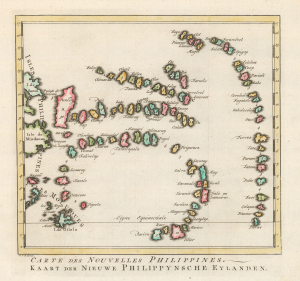
Carte des Nouvelles Philippines. / Kaart der Nieuwe Philippynsche Eylanden.
$250.00
Acquire
- Digital Map Information
- Suitable for large format printing
- Full resolution TIFF file
- ICC color profile embedded
- Delivered instantly via download link
This is a 1759 Dutch-edition of Jacques-Nicolas Bellin's map of the Caroline Islands, preserving geographical knowledge provided by indigenous Carolinian voyagers who were stranded in the Philippines in 1696. Its conspicuous numbers measure distance and island size in days of sailing, carrying an indigenous maritime understanding of the archipelago into European print. Published with French and Dutch titles, the map descends from the account and sketch communicated by the Jesuit Paul Klein, rather than from a European survey of the islands. (more details)