
Schley, Jacob van der (sold)

Jacob Van der Schley (1715 - 1779) was a prominent Amsterdam engraver and draftsman based out of Amsterdam. Schley apprenticed under portrait engraver Bernard Picart, whose style he imitated. He is said to have completed several of Picart's portraits following his master's death. While Schley is primarily known for his work as a portraitist and illustrator, he also has a considerable cartographic corpus. He is known to have worked with Bellin, Hondt, and Provost, among others.
Stunning map of an legendary Persian Gulf trade port.
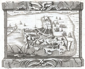
Ormus oude Jerun. ⁄ 't Eiland Ormus, of Jerun.
sold
- Digital Map Information
- Suitable for large format printing
- DPI: 300
- File Size: 3.38 MB
- File Type: ZIP / TIFF
- ICC color profile embedded
- Delivered instantly via download link
I travelled next from the land of 'Oman to the land of Hurmuz. Hurmuz is a city on the sea-coast, and is also called Mughistan. Opposite it in the sea is New Hurmuz, and between them is a sea passage of three farsakhs. We came to New Hurmuz, which is an island ... (more details)
Highly desirable early plan of Tokyo or Edo.
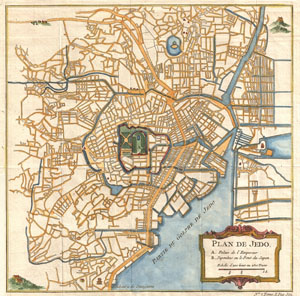
Plan de Jedo.
sold
- Digital Map Information
- Suitable for large format printing
- DPI: 300
- File Size: 4.44 MB
- File Type: ZIP / TIFF
- ICC color profile embedded
- Delivered instantly via download link
This is an attractive and highly desirable c. 1752 map of Edo or Tokyo, Japan. Issued by Bellin and Schley for Prevost's Histoire Generale des Voyages , this map is cartographically based on a 1702 map of the same issued by Scheuchzer and Kaempfer, which ... (more details)
An Attractive 18th Century Map of Siam.
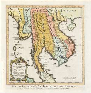
Carte des Royaumes de Siam, de Tunquin, Pegu, Ava, Aracan etc./ Kaart der Koningryken Siam, Tonkin, Pegu, Ava, Arakan etc./ Om te dienen tot de Historische Beschryving der Reizen.
sold
- Digital Map Information
- Suitable for large format printing
- Full resolution TIFF file
- ICC color profile embedded
- Delivered instantly via download link
This is the 1755 Dutch edition of Bellin's map of Southeast Asia, engraved by Jakob van der Schley for inclusion in the Dutch edition of Abbe Prévost's Histoire Générale des Voyages. Centered on the Chao Phraya River, this map covers from the Kingdom of Aracan to the Gulf of Tonkin and from China to the Malay Peninsula, including the modern day nations of Thailand, Cambodia, Laos, Vietnam, Burma, and Malaysia. This map represented a considerable advancement of mapping of the interior of Southeast Asia over the maps of De l'Isle which preceded it, with numerous cities, fortifications, temples, and mountain ranges noted. The map identifies the cities of Siam (Ayutthaya), Bangkok, Lau Chang (Luong Prabong), and Pegu. Many of the islands in the Gulf of Thailand, including Samui, and in the Andaman Islands are noted as well. (more details)
Beautiful bird's eye-view of Acapulco Mexico.
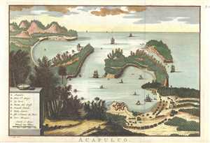
Acapulco.
sold
- Digital Map Information
- Suitable for large format printing
- DPI: 300
- File Size: 5.09 MB
- File Type: ZIP / TIFF
- ICC color profile embedded
- Delivered instantly via download link
This is a beautiful c. 1757 map of Acapulco de Juarez, commonly known as Acapulco, Mexico by Jan van Schley. Features the Acapulco Bay and its fortified port in incredible detail. Important buildings, forests and mountains are depicted in profile, give a ... (more details)
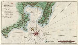
Plan du Port de Chequetan ou Seguataneo a 17 Deg: 36 Min de Latitude Septe. / Plan van de Haven van Chequetan of Seguataneo Leggende op de Noorderbreette van 17 Gr. 36 Min.
sold
- Digital Map Information
- Suitable for large format printing
- File Size: 2.37 MB
- File Type: ZIP / TIFF
- ICC color profile embedded
- Delivered instantly via download link
An extremely attractive 1765 map of the Mexican harbor of Zihuatanejo by George Anson and Jan van Schley. Details the harbor beautifully showing mountains, waterways, and trees as well as offering detailed depth soundings and nautical references. ... (more details)
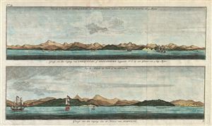
Gezigt van den Iagang van Chequetan, of Seguataneo leggende N.O. op een asstand van 5 Eng. Mylen. / Gezigt van den Ingang van de Haven van Acapulco.
sold
- Digital Map Information
- Suitable for large format printing
- File Size: 5.74 MB
- File Type: ZIP / TIFF
- ICC color profile embedded
- Delivered instantly via download link
A pair of appealing 1765 nautical views of the Mexican harbors of Acapulco and Zihuatanejo by George Anson and Jan van Schley. These shore profiles include beautiful renderings of 18th century sailing ships as well as still identifiable coastal ... (more details)
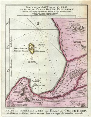
Carte de la Baye de la Table et Rade du Cap de Bonne Experance. Kaart der Tavelbaai en Ree van Kaap de Goede Hoop.
sold
- Digital Map Information
- Suitable for large format printing
- DPI: 300
- File Size: 2.76 MB
- File Type: ZIP / TIFF
- ICC color profile embedded
- Delivered instantly via download link
This map is a c.1773 map of the Cape of Good Hope and Cape Town, South Africa. Attributed to French cartographer Jacques-Nicholas Bellin, this map was issued for the Dutch edition of Provost's Histoire des Voyages . Beautifully rendered ... (more details)
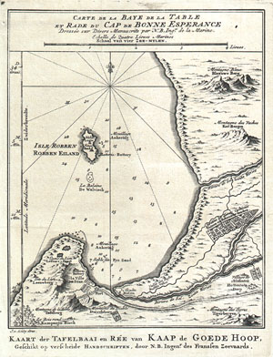
Carte de la Baye de la Table et Rade du Cap de Bonne Experance Dressee sur Divers Manuscrits par N. B. Ing' De la Marine. / Kaart der Tavelbaai en Ree van Kaap de Goede Hoop, Geschikt op verscheide Handschriften, door N.B. Ingenr. Des Franssen Zeevaards.
sold
- Digital Map Information
- Suitable for large format printing
- Full resolution TIFF file
- ICC color profile embedded
- Delivered instantly via download link
This map is a c. 1773 map of the Cape of Good Hope and Cape Town, South Africa. Attributed to French cartographer Jacques-Nicholas Bellin, this map was issued for the Dutch edition of Provost's Histoire des Voyages…. Beautifully ... (more details)
Canaan Before the Arrival of the Israelites
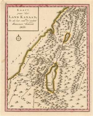
Kaart van het Land Kanaan zo als het van de oudste Inwooners bewoond werd.
sold
- Digital Map Information
- Suitable for large format printing
- DPI: 600
- File Size: 5.31 MB
- File Type: ZIP / TIFF
- ICC color profile embedded
- Delivered instantly via download link
This rare 1780 map of Canaan presents the region of modern-day Israel, Lebanon, Jordan and Syria. The map shows Canaan prior to the arrival of the Israelites. It shows the kingdoms of the Philistines, Canaanites, Amelekites, Ammonites, and the Kingdom of Bashan. The Jordan River, the sea of Galilee and the Dead Sea are all shown. The doomed cities of Zeboim, Adama, Sodom and Gomorrah are all shown - unusually, for a holy land map of this period - on the shores of the Dead Sea, rather than in the middle of it. The map's topography i+K225:K22s based on contemporary cartographic data, but it was not intended to depict the 18th century Near East: rather, the place names are drawn from Biblical sources, reinforced with geographical data of ancient geographers. (more details)
Extremely Rare, Attractively Engraved Map of Europe, Africa and Asia.
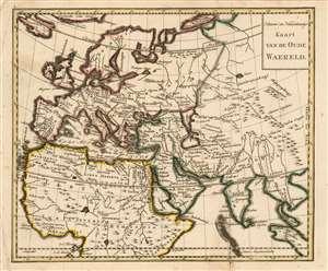
Nieuwe en naauwkeurige kaart van de Oude Waereld.
sold
- Digital Map Information
- Suitable for large format printing
- DPI: 600
- File Size: 6.28 MB
- File Type: ZIP / TIFF
- ICC color profile embedded
- Delivered instantly via download link
This rare 1780 map of Europe, Northern Africa and Western Asia presents - with some notable exceptions - the parts of the world known to the Roman Empire during the Biblical period. Most of the place names are those which would have been familiar to Ptolemy, Pliny and Josephus. The geography shown is not ancient, however. Rather than being modeled after Ptolemy's mapping of the world known during the Roman era, the map reflects the geographical knowledge of the 18th century. Neither Nova Zemla nor Iceland, both shown here, were known to ancient geographers; and although distorted, both the Indian and Malay peninsulae are shown as they were understood after the discovery era. The mapmaker follows many of the early translators of Ptolemy in identifying the island of Taprobana as Sri Lanka. Similarly, Goa and Cambodia are marked and named on the map. Central Asia is labeled (libeled?) as the domain of cannibals and horse-eaters. The map was intended to accompany a book of Biblical geography, and to help the reader place the events of religious antiquity in the context of a modern, expanding world. (more details)
The Fertile Crescent of the Biblcal Era
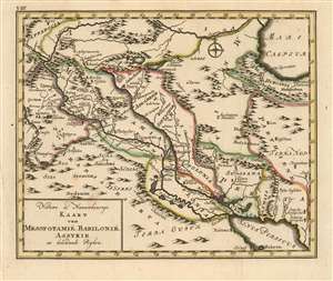
Nieuwe en Naauwkeurige Kaart van Mesopotamië, Babilonië, Assyrie en belendende Ryken.
sold
- Digital Map Information
- Suitable for large format printing
- DPI: 600
- File Size: 5.39 MB
- File Type: ZIP / TIFF
- ICC color profile embedded
- Delivered instantly via download link
This rare 1780 map of Mesopotamia presents the region of modern-day Syria, Iraq and western Iran. the map is centered on the courses of the Tigris and Euphrates, spanning north and south from the Caspian Sea to the Persian Gulf and west to east from Baalbek in Lebanon to Shiraz in Iran. The map's topography is based on contemporary cartographic data, but it was not intended to depict the 18th century Near East: rather, the place names are drawn from Biblical sources, reinforced with geographical data of ancient geographers - primarily referencing the period of the Bablylonian Captivity. Other features include Mount Ararat, reputed to be the mountain where Noah's ark came to rest after The Flood. (more details)
Extremely Rare, Attractively Engraved Map of the Holy Land.
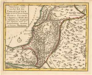
Naauwkeurige kaart van het ryk der Israëlieten, zodanig het zich ten tyden der Koningen David en Salomon, van Egipten en de Roode Zee tot Hemath en den Euphrat heest uitgestrekt, nevens het Seenächtig Arabië en berzelver Woestynen.
sold
- Digital Map Information
- Suitable for large format printing
- DPI: 600
- File Size: 5.69 MB
- File Type: ZIP / TIFF
- ICC color profile embedded
- Delivered instantly via download link
This rare 1780 map of the Holy Land presents the region showing the kingdom of Israel during the reigns of King David and King Solomon. The map extends from the Mediterranean Sea and the Red Sea to the upper Euphrates River. The map's topography is shown pictorially and for the most part fancifully. The place names are drawn from Biblical sources, as is appropriate for a map intended to accompany a book of Biblical geography, but the map also draws from ancient geographers such as Pliny, and Josephus. (more details)
The Kingdoms of Herod the Great
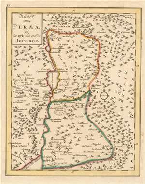
Kaart van Peraea, of het Ryk van over de Jordane.
sold
- Digital Map Information
- Suitable for large format printing
- DPI: 600
- File Size: 5.17 MB
- File Type: ZIP / TIFF
- ICC color profile embedded
- Delivered instantly via download link
This rare 1780 map of the Kingdom of Peraea presents the region of modern-day Israel, Jordan and Syria. the map is centered on the course of the River Jordan, from its sources north of the Sea of Galilee to the Dead Sea. The map includes Galilaea and Samaria to the west but focuses on Peraea and Batanaea. These were both the domains of Herod the Great in the first century C.E. The map's topography is based on contemporary cartographic data, but it was not intended to depict the 18th century Near East: rather, the place names are drawn from Biblical sources, reinforced with geographical data of ancient geographers - in particular Pliny the Elder, and Josephus. (more details)