
Senryūdō (川流堂, 川流所)

Senryūdō (川流堂, sometimes 川流所; fl. c. 1888 - 1950) was a Tokyo-based publisher that often produced maps of Japan and its empire in the early - mid 20th century/
AKA: 川流堂, 川流所
Massive Pre-War map of Japan's imperial ambitions.
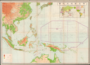
最新南支南洋大地圖 / [Latest Map of Southern China, Southeast Asia, and Northern Australia].
$1,800.00
Acquire
- Digital Map Information
- Suitable for large format printing
- Full resolution TIFF file
- ICC color profile embedded
- Delivered instantly via download link
This is a very large and rare 1937 Kobayashi Matashichi map of southern China, Southeast Asia, and the South Pacific. The map anticipates Japanese interest in this vast and resource-rich region, an area soon to be engulfed in the Pacific War (1941 - 1945) and subsumed to Japanese imperial ambitions. Given its tremendous size and detail, it is likely this map was prepared for internal military use in anticipation of Japanese expansion into the Pacific, the East Indies, Southeast Asia, and China. Centered on the strategically critical Philippine Islands, coverage extends from Korea to Australia and from the Bay of Bengal to Micronesia. (more details)