
Sherwood, Neely and Jones

Sherwood, Neely and Jones (active 1806-1824) were a London firm of print and book publishers; they produced a broad array of folding maps and city plans, including school atlases, and editions of John Melish' map of the United States.
End of the Edwardian Era, dawn of the Victorian.
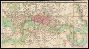
Map of London, and its Environs 1814.
$1,500.00
Acquire
- Digital Map Information
- Suitable for large format printing
- DPI: 600
- File Size: 72.21 MB
- File Type: ZIP / TIFF
- ICC color profile embedded
- Delivered instantly via download link
This is a scarce, folding map of London published in 1814 by J. M. Richardson to accompany John Lockie's Gazetteer, Topography of London. (more details)