
Shimizu Tsunetaro (清水常太郎)

Shimizu Tsunetaro (清水常太郎; fl. c. 1892 - 1905) was a Japanese cartographer active in the 1890s based in Kyoto and Osaka. Little else is known about his life and work. His maps coincided with Japan's imperial expansion, focusing on Taiwan, Korea, and China, though he also produced maps of Japanese cities such as Nagasaki and Saga.
AKA: 清水常太郎
Japan's Bid for Hegemony in East Asia.
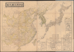
日清韓三國地圖 / [Map of Japan, China, and Korea].
$950.00
Acquire
- Digital Map Information
- Suitable for large format printing
- Full resolution TIFF file
- ICC color profile embedded
- Delivered instantly via download link
This is a large-format 1894 map of East Asia prepared by Shimizu Tsunetarō. It presents the region during the opening phases of the First Sino-Japanese War (1894 - 1895), which would redefine the traditional relationship between China and its neighbors. (more details)
Japanese diplomatic and propaganda con-job on the Qing.
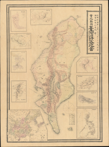
Detailed Map of Taiwan Field Survey. / 實地踏測台灣詳密地圖
$11,000.00
Acquire
- Digital Map Information
- Suitable for large format printing
- Full resolution TIFF file
- ICC color profile embedded
- Delivered instantly via download link
This 1895 Nakamura Yoshimatsu map of Taiwan is one of the most unsung but influential examples of persuasive cartography ever published. The large-scale map of Taiwan appeared at the end of the First Sino-Japanese War (August 1, 1894 - April 17, 1895), just prior to the Treaty of Shimonoseki (April 17, 1895) and the Japanese invasion of Taiwan (May 29, 1895 - October 21, 1895). The map, attributed to a likely fictional British naval officer named John Waters, employs creative cartography to reshape Taiwan, while retaining the overall area, effectively reducing the size of Qing-controlled Formosa and increasing the size of the ungoverned 'savage zones' - a ploy that played into the Japanese position that the Qing did not truly possess the island. It was likely presented at the Shimonoseki negotiations, where the Japanese were able to take advantage of Qing China's infamous lack of cartographic knowledge about Formosa to formally seize the island. This is the first edition of this map, published on January 20, 1895. It also accompanies the booklet Taiwan-tō Chishi-yō (臺灣島地誌撮要), a combination gazetteer of Taiwan and historiographical justification of the Japanese seizure of the island using Confucian political morality and just-war rhetoric. (more details)