
1894 Shimizu Folding Map of Japan, Korea, and Qing China, First Sino-Japanese War

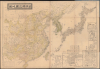

日清韓三國地圖 / [Map of Japan, China, and Korea].
Japan's Bid for Hegemony in East Asia.
- Digital Map Information
- Suitable for large format printing
- Full resolution TIFF file
- ICC color profile embedded
- Delivered instantly via download link
Japan's Bid for Hegemony in East Asia.
This is a large-format 1894 map of East Asia prepared by Shimizu Tsunetarō. It presents the region during the opening phases of the First Sino-Japanese War (1894 - 1895), which would redefine the traditional relationship between China and its neighbors.A Closer Look
The map covers Japan, Korea, and China proper, with a portion of Manchuria and Mongolia, but not Tibet and Chinese Turkestan (Xinjiang), which were also under Qing suzerainty or rule. Major cities, administrative centers, administrative boundaries, roads, railways, mountains, waterways, the Great Wall of China, and maritime features such as shipping routes and lighthouses are marked throughout. The islands around Taiwan are given an especially detailed treatment. A table of distances appears next to the legend, denoting the distance traveled on the railway line from Tianjin to Shanhaiguan (where the Great Wall meets the sea), nearly due east of Beijing. Six inset maps appear, depicting (moving clockwise from top) Seoul, Wonsan, Busan, Beijing, Shanghai, and Incheon.The First Sino-Japanese War (1894 - 1895)
Tokugawa Japan and Qing China faced similar problems in the mid-19th century: overpopulation, domestic unrest, ineffective governance, weak leaders, and, finally, foreign threats from Western powers. Both countries were on the receiving end of 'gunboat diplomacy,' which forced them to open ports for foreign trade, allow foreigners to reside there, and tolerate a degree of foreign cultural influence, such as Christian missionaries. The combination of pent-up discontent and sudden shock from outside the system caused both countries to undergo a period of upheaval and crisis.Their fortunes diverged, however, in that the Qing managed to hold on to power (just barely) while the Tokugawa fell and were replaced by a new regime led by the Meiji Emperor. The new government came to power promising to expel foreign influences, but then turned around to embrace them, recognizing that Japan's best hope for survival was to imitate the Western imperial powers (a realization the Tokugawa had also come to, albeit too late to save themselves).
From the Meiji Restoration in 1868 onwards, drastic changes were implemented, often against public opposition, to the extent that this agenda has been dubbed a 'revolution from above.' Within a few years, Japan was already eyeing the Ryukyu Islands and Taiwan, and looking to expand its influence in Korea. The latter goal was greatly aided by the 1876 Treaty of Ganghwa, Japan's own 'unequal treaty' imposed on Korea.
These moves were anathema to the traditional order in East Asia, where China was clearly on top and other countries were secondary powers. Joseon Korea was effectively a protectorate of China, so increasing Japanese influence there was disturbing to the Qing, while Taiwan was a territory of the Qing realm itself (initially part of Fujian Province, then upgraded to a province itself in 1887). By the 1890s, Japan was clearly in the ascendant, while the Qing were beset and could not afford a major conflict.
The ultimate catalyst for a war between China and Japan came with the Donghak Peasant Uprising that began in January 1894 in Korea and gained rapid momentum (one of the rebels' main grievances was growing Japanese influence in Korea). In reaction, nominally to protect Japanese citizens and property, Japanese troops were dispatched to Korea in violation of China's protectorate, leading to war.
The Qing had attempted to modernize their military in the late 19th century, but the resulting 'Self-Strengthening Movement' was only a partial success. Its limitations were on clear display as Japan's thoroughly modernized military sprang from one victory to another on land and sea. The Qing had no choice but to sign a humiliating treaty, surrendering Taiwan and their influence in Korea. Japan's victory was shocking to many in the West and signaled Japan's rise as a proper regional, if not a world, power. In Japan, the war led to a surge of popular nationalism that would carry the country to further wars and expansionism in East Asia. In China, the war resulted in calls for more drastic reform, which were stymied, and spelled even greater troubles for the Qing Dynasty, which would collapse within 20 years.
Publication History and Census
This map was prepared (edited) by Shimizu Tsunetarō (清水常太郎), printed by Nakata Sadanori (中田貞矩) on August 19, 1894 (Meiji 27), and published on August 30 by Nakamura Yoshimatsu (中村芳松). A red seal stamp on the verso is not entirely legible, but does strongly suggest that the original owner resided in Nagoya (名古屋). The map is quite rare, only being held by the National Museum of Taiwan History, Waseda University, and Tokyo Keizai University. The National Diet Library holds a very similar map by Shimizu published the following month with a slightly different title (日清韓三國輿地圖) and two others published the same year but no specific date with similar titles (日清韓三國明細全圖 and 日清韓三國地圖及満洲明細). Shimizu was very active in the years 1894 - 1895, as were many other Japanese cartographers and publishers, responding to popular demand for information about the war. Indeed, in the text box at bottom-left, Shimizu encourages the viewer to consult his other maps if they wish to have a more detailed sense of the geography of Korea (朝鮮全圖) or China (清國本部輿地圖). Shimizu and Nakamura also collaborated on a very bizarre and wildly inaccurate contemporary map of Taiwan that was likely meant as a diplomatic ruse (see our TaiwanFormosa-nakamura-1895-3).Cartographers
Shimizu Tsunetaro (清水常太郎; fl. c. 1892 - 1905) was a Japanese cartographer active in the 1890s based in Kyoto and Osaka. Little else is known about his life and work. His maps coincided with Japan's imperial expansion, focusing on Taiwan, Korea, and China, though he also produced maps of Japanese cities such as Nagasaki and Saga. Further Details...
Nakata Sadanori (中田貞矩; fl. c. 1894 - 1905) was a creator of maps and a printing technician who was active in Osaka during the late Meiji era. He studied copperplate engraving under Mori Kinseki (森琴石, 1843 - 1921) and published maps such as the 'General Map of the Qing Empire' (清國本部輿地圖) and 'Map of Japan' (日本輿地圖) during the 1880s, and was particularly renowned for his printing techniques utilizing halftone screens. Further Details...
Nakamura Yoshimatsu (中村芳松; fl. c. 1882 - 1906) was a major Japanese book and map publisher active in Osaka during the late 19th and early 20th centuries. The firm's output varied, but mostly consisted of maps, geographical texts, and works discussing or glorifying the military. Further Details...
Condition
Very good. Two small areas of worm holing. Attached to original binder.
References
OCLC 905622630. National Museum of Taiwan History Registration No. 2006.002.1197.