
Ugo, Donofrio

Donofrio Ugo (fl. 1946-) was an American artist. He is credited with drawing several maps published by Boston cartographer Richard Friend Lufkin in the late 1940s.
An Attractive and Entertaining Pictorial Map of Cape Cod, Massachusetts
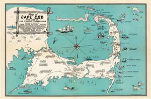
Map of Cape Cod the Land of Our Pilgrim Forefathers wherein is Indicated Cape Cod's Fifteen Towns of Provincetown, Reruro, Wellfleet, Eastham, Orleans, Brewster, Chatham, Harwich, Dennis, Yarmouth, Barnstable, Sandwich, Bourne, Mashpee, Falmouth. Actual duplications of many shipwrecks and landmarks. Designed and Planned by Edward Rowe Snow. Drawen by Ugo Donofrio. 1946.
$450.00
Acquire
- Digital Map Information
- Suitable for large format printing
- File Size: 7.47 MB
- File Type: ZIP / TIFF
- ICC color profile embedded
- Delivered instantly via download link
A charming 1946 pictorial map of Cape Cod and its towns, created by New England author and historian Edward Rowe Snow. A lover of all things piratical and nautical, Snow brusquely marks out the towns of Cape Cod with banners, but indulges himself in his depictions of ships and shipwrecks, sea birds, whales and even a sea monster menacing Provincetown. The shipwrecks are not generic, but rather are specific, named ships ranging from the Pirate ship ‘Whidah’ (Whydah Gally, a slaver and pirate ship sunk in 1717) to Submarine S-4 (SS-109, a U.S. Submarine sunk in 1927). Camp Edwards (a major WWII training ground) is marked on the map, as is Hyannis Airport. (more details)