1946 Pictorial Map of Cape Cod, Massachusetts
CapeCod-snow-1946$450.00

Title
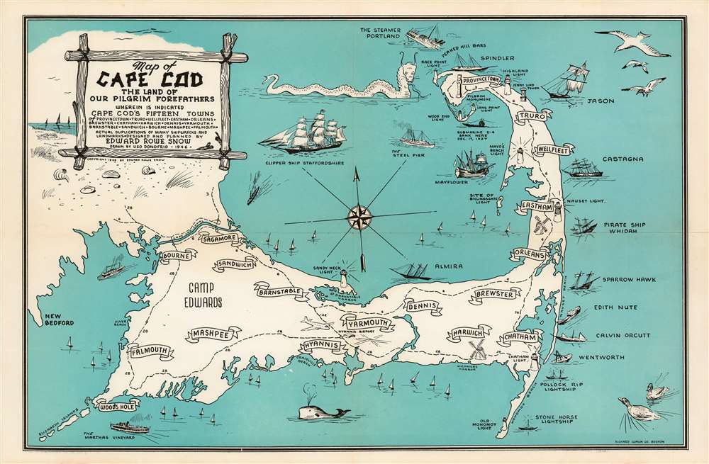
Map of Cape Cod the Land of Our Pilgrim Forefathers wherein is Indicated Cape Cod's Fifteen Towns of Provincetown, Reruro, Wellfleet, Eastham, Orleans, Brewster, Chatham, Harwich, Dennis, Yarmouth, Barnstable, Sandwich, Bourne, Mashpee, Falmouth. Actual duplications of many shipwrecks and landmarks. Designed and Planned by Edward Rowe Snow. Drawen by Ugo Donofrio. 1946.
1946 (dated) 10.25 x 15.75 in (26.035 x 40.005 cm)
1946 (dated) 10.25 x 15.75 in (26.035 x 40.005 cm)
Description
A charming 1946 pictorial map of Cape Cod and its towns, created by New England author and historian Edward Rowe Snow. A lover of all things piratical and nautical, Snow brusquely marks out the towns of Cape Cod with banners, but indulges himself in his depictions of ships and shipwrecks, sea birds, whales and even a sea monster menacing Provincetown. The shipwrecks are not generic, but rather are specific, named ships ranging from the Pirate ship ‘Whidah’ (Whydah Gally, a slaver and pirate ship sunk in 1717) to Submarine S-4 (SS-109, a U.S. Submarine sunk in 1927). Camp Edwards (a major WWII training ground) is marked on the map, as is Hyannis Airport.
Publication History and CensusThis piece is scarce on the market. It is neglected in institutional collections: it appears only in the Harvard University library and the Family History Library in Salt Lake City. We see only one example in auction records from 2017.
CartographerS
Edward Rowe Snow (August 22, 1902 – April 10, 1982) was an American author and historian. Born in Withrop, Massachusetts, Snow graduated from Harvard University and subsequently from Boston University with an M.A. Snow married Anna-Myrle Haegg on July 8, 1932 with whom he had one daughter. Snow worked as a high school teacher in Winthrop, Massachusetts for a time. He served as a first lieutenant with the XII Bomber Command during World War II and was wounded in North Africa in 1942. He was discharged in 1943 due to the wounds he received. Snow also worked as a daily columnist at The Patriot Ledger, a newspaper in Quiuncy, Massachusetts, from 1957 – 1982. He is widely remembered for his stories about pirates and other nautical subjects. Snow is the author of over forty books many shorter works. Over the course of his life, Snow was the author of over 100 publications, mostly concerning New England coastal history. He is also well remembered for maintaining the tradition of the 'Flying Santa' for over forty years (1936 – 1980). Begun in 1929, the 'Flying Santa' tradition was organized as a way to drop Christmas gifts out of airplanes to lighthouse keepers and their families along the New England coast. More by this mapmaker...
Richard Friend Lufkin (1895-1963) was a professional civil engineer and head of the Richard Lufkin Company (engineers, draftsmen, artists, and cartographers). He was an Abraham Lincoln scholar and published a number of writings and illustrated maps revolving around Lincoln and his time spent in New England. His company produced a number of pictorial maps focused on Massachusetts, as well as for a number of years printing the map of Boston's MTA. Learn More...
Donofrio Ugo (fl. 1946-) was an American artist. He is credited with drawing several maps published by Boston cartographer Richard Friend Lufkin in the late 1940s. Learn More...
Condition
Very good condition. Original fold lines with virtually no wear.
References
OCLC 866554733.