
Vital, Adolfo

Adolfo Vital (1873 - 1944) was an engineer and cartographer active in Argentina in the early 20th century. His list of known works is limited, including only three highly-detailed maps, a cadastral map of the areas immediately around Buenos Aires (' Nuevo Plano Catastral de los Alrrededores de Buenos Aires,' made in conjunction with Enrique Roux and published by Hugo Bonvicini), a similar map of Bahía Blanca ('Plano topográfico y catastral del Partido de Bahía Blanca'), and a large-format folding map of the wider province of Buenos Aires ('Mapa de la Provincia de Buenos Aires'). He is distinct from a contemporary Italian author of the same name who was an expert on the local history of his native Conegliano in the Veneto.
Argentina's Population, Railway, and Agriculture Boom.
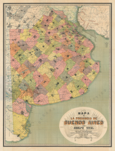
Mapa de la Provincia de Buenos Aires.
$2,500.00
Acquire
- Digital Map Information
- Suitable for large format printing
- File Size: 110.63 MB
- File Type: ZIP / TIFF
- ICC color profile embedded
- Delivered instantly via download link
This is a large-format 1910 chromolithograph map of Buenos Aires Province in Argentina, prepared by Adolfo Vital and published by Guillermo van Woerden to coincide with the Argentinian Centennial. It documents the province at a time of rapid immigration, expansion of railways, and increased agricultural output. (more details)