
1910 Vital City Plan of Buenos Aires, Argentina

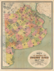
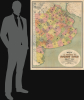
Mapa de la Provincia de Buenos Aires.
Argentina's Population, Railway, and Agriculture Boom.
- Digital Map Information
- Suitable for large format printing
- File Size: 110.63 MB
- File Type: ZIP / TIFF
- ICC color profile embedded
- Delivered instantly via download link
Argentina's Population, Railway, and Agriculture Boom.
This is a large-format 1910 chromolithograph map of Buenos Aires Province in Argentina, prepared by Adolfo Vital and published by Guillermo van Woerden to coincide with the Argentinian Centennial. It documents the province at a time of rapid immigration, expansion of railways, and increased agricultural output.A Closer Look
This striking map depicts the Province of Buenos Aires, named for and largely centered around the eponymous city near its northeastern section. However, the city has not been part of the province since 1880, when it was federalized, and the provincial capital moved to La Plata. The province is divided into 105 districts (partidos), color-shaded for distinction and updated with the latest information (including new districts like Alberti, formed in 1910), which are crisscrossed by survey lines. Cities, towns, colonias, waterways, and coastal features are labeled throughout. Both roads and railways are traced, demonstrating the density of the railway network at its peak, when the long-extant British dominance of the railways was challenged by new private companies and state-backed enterprises, both domestic and foreign. The railway building spree was both driven by and further encouraged the rapidly growing agricultural production of the province's large estates and colonias.Historical Context
At the dawn of the 20th century, the Province of Buenos Aires underwent a drastic transformation fueled by a large wave of European Immigration, especially from Italy and Spain. Between 1880 and 1914, millions of immigrants arrived at the port of Buenos Aires, with many venturing into the province's vast interior. This influx was encouraged by the Argentine government, which aimed to modernize the nation through European labor. While many immigrants initially settled in urban tenements, a significant number moved to the countryside to work as tenant farmers or sharecroppers, fundamentally altering the region's demographic fabric and laying the foundations of its diverse cultural identity. Roughly one-third of the population of Buenos Aires Province and several other provinces were immigrants at this time. In some places, such as Patagonia, the number was even higher.Nonetheless, the settlement process was fraught with systemic challenges and social tension. Unlike the United States' Homestead Act, land ownership in Buenos Aires Province remained concentrated in the hands of a few wealthy landowners with huge estates, leaving most immigrants unable to purchase the land they tilled. This lack of access to land ownership led to growing unrest among rural workers, leading ultimately to the 1912 'Grito de Alcorta' strike/rebellion, which did lead to some protections for workers through the creation of the Federación Agraria Argentina. Despite these hardships, the era saw the rapid expansion of the railway network and the rise of agricultural colonies, which integrated the province into the global economy as a premier exporter of grain and beef, cementing its status as Argentina's economic heart.
Chromolithography
Chromolithography, sometimes called oleography, is a color lithographic technique developed in the mid-19th century. The process uses multiple lithographic stones, one for each color, to yield a rich composite effect. Generally, a chromolithograph begins with a black basecoat upon which subsequent colors are layered. Some chromolithographs used 30 or more separate lithographic stones to achieve the desired effect. Chromolithograph color can be blended for even more dramatic results. The process became extremely popular in the late 19th and early 20th centuries when it emerged as the dominant method of color printing. The vivid color chromolithography made it exceptionally effective for advertising and propaganda.Publication History and Census
This map was prepared by surveyor Adolfo Vital and published by Guillermo van Woerden in Buenos Aires. However, it was notably printed in Leipzig, Germany, by the 'Instituto Geográfico de C. Opitz.' This fact reflects the importance of transatlantic connections among German speakers at this time, as well as the high reputation of the European printing industry. It was not uncommon for maps published in South America at the turn of the 20th century to be printed in Germany, France, or Britain. The map is undated, but the dates given on either side of the illustration in the title cartouche indicate that it was published in 1910 in tandem with the Argentine Centennial. The only known institutional holding of this map is with the Médiathèque du Musée du Quai Branly.Cartographers
Adolfo Vital (1873 - 1944) was an engineer and cartographer active in Argentina in the early 20th century. His list of known works is limited, including only three highly-detailed maps, a cadastral map of the areas immediately around Buenos Aires (' Nuevo Plano Catastral de los Alrrededores de Buenos Aires,' made in conjunction with Enrique Roux and published by Hugo Bonvicini), a similar map of Bahía Blanca ('Plano topográfico y catastral del Partido de Bahía Blanca'), and a large-format folding map of the wider province of Buenos Aires ('Mapa de la Provincia de Buenos Aires'). He is distinct from a contemporary Italian author of the same name who was an expert on the local history of his native Conegliano in the Veneto. Further Details...
Guillermo van Woerden (van Woerden y Cia, Librería Alemana de Guillermo van Woerden; fl. c. 1890 - 1925) was a bookseller and publisher based in Buenos Aires at the turn of the 20th century, the proprietor of the German Bookstore of Guillermo van Woerden (van Woerden y Co.). Though details of his biography are very limited, he was almost certainly born in Germany (or, given his name, perhaps the Netherlands) and then emigrated to Argentina, along with many other German-speakers in the late 19th century, ensuring a ready market for his publications. Van Woerden filled a niche by selling German-language publications, but most of his known published works were in Spanish, including maps ('Mapa de la Provincia de Buenos Aires,' 'Plano de Gobernación de Chubut'), scientific bulletins (Boletín de la Academia Nacional de Ciencias), and educational materials (Catálogo ilustrado de materiales de enseñanza). Further Details...
Carl Albert Opitz (1847 - 1924) was a map and atlas publisher based in Leipzig, Germany in the late 19th - early 20th centuries. His Geographische Anstalt was best known for early 20th century works such as Eisenbahn- und Verkehrs-Atlas von Europa, Reise- und Verkehrskarte von Mittel-Europa, as well as the later (1940s) Taschen-Weltatlas and Postwar Mitteldeutschen Heimatatlas. The company continued after its founder's death and passed to another Carl Opitz, almost certainly the founder's son. It survived the Second World War but seems to have closed down around 1960. Further Details...
Condition
Excellent. Accompanies original binder.
References
OCLC 800622440.