
Williams, C. S.

C. S. Williams (1800 - 18??) was an American engraver and publisher active in Philadelphia during the middle part of the 19th century. Williams is elusive and we have been unable to definitively isolate much information about him. He may have been born in New York. He engraved for Her Schenck Tanner (1796 0 1858) and his imprint and copyright is associated with several important Tanner atlas maps issued between 1845 and 1846. Similarly, his imprint carries over to Tanner legacy maps issued by Samuel Augustus Mitchell (1792 - 1868) maps until about 1850. There are references to an engraver by the name of C. S. Williams in New Haven, Connecticut, active in the 1830s, as well as to a C. S. Williams active in Ohio from around 1850, where he published a various city directories, including one for Cincinnati, Columbia, Dayton, Zanesville, Stubenville, et al.. There is also a C. S. Williams identified as a Surveyor and Land Agent in Iowa City, Iowa, c. 1858. It is unclear if these are the same person, or, completely unrelated individuals.
Texas on the eve of Statehood.
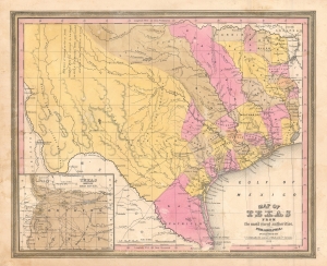
Map of Texas from the most recent authorities.
$950.00
Acquire
- Digital Map Information
- Suitable for large format printing
- DPI: 600
- File Size: 12.43 MB
- File Type: ZIP / TIFF
- ICC color profile embedded
- Delivered instantly via download link
A rare 1845 / 1846 example of the C. S. Williams / J. H. Young / S. A. Mitchell map of Texas, published in the final days of the Republic of Texas just as Texas was preparing to join the United States. Coverage includes Texas at its fullest extent, reaching from Santa Fe and the Rio Grande del Norte to the Sabin River and extending as far north as the Arkansas River (plus a stovepipe encompassing the Green Mountains not fully illustrated). Northwestern Texas is incorporated via an inset in the lower left. (more details)