This item has been sold, but you can get on the Waitlist to be notified if another example becomes available, or purchase a digital scan.
1850 Mitchell Map of Texas
Texas-mitchell-1850$550.00

Title
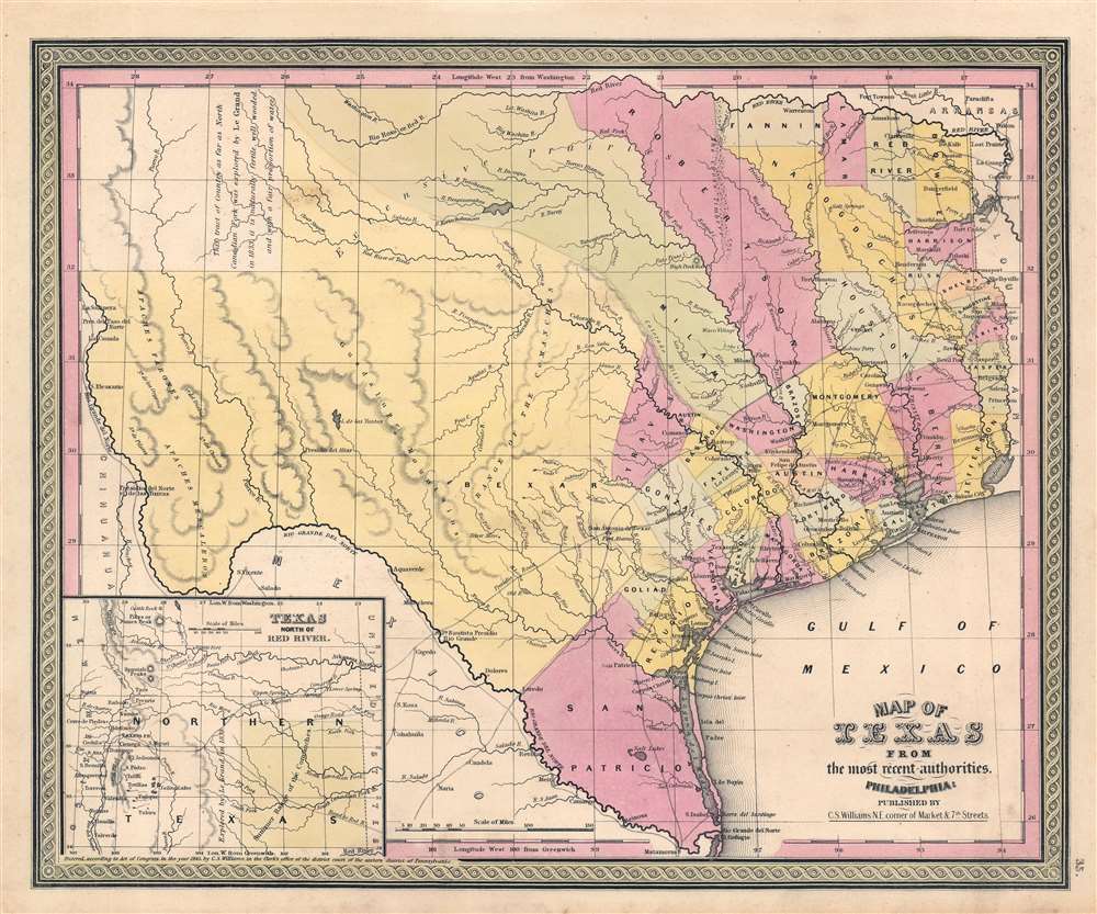
Map of Texas from the most recent authorities.
1850 (undated) 12.5 x 15.5 in (31.75 x 39.37 cm) 1 : 3300000
1850 (undated) 12.5 x 15.5 in (31.75 x 39.37 cm) 1 : 3300000
Description
A unique transitional state of the 1850 Samuel Augustus Mitchell / C. S. Williams map of Texas. Based upon the Tanner/Burroughs map, coverage here has been updated in manuscript by the publisher to reflect the Compromise of 1850, in which the Republic of Texas Era borders were reduced to the state's current configuration. Here the map is clearly divided between Bexar County, in yellow, and the more populated parts of Texas to the east. The county structure there is sophisticated and reflects numerous updates and revisions over the original 1845 Tanner plate.
Compromise of 1850 (in manuscript)
As this map went to press, the Compromise of 1850 was passed. This act ceded much of the original Republic of Texas western territory to the federal government in exchange for that entity taking over state's substantial war debt. The Compromise dramatically and permanently changed Texas's cartographic profile. Here the engraved map is unchanged from the previous edition, but the western border of Texas, particularly in the inset, has been revised in pencil manuscript and wash color to reflect the Compromise. These changes, due to the consistency of the old publisher's color, were doubtless performed by the publisher at the time of publication - suggesting an early 1850 variant, issued before the changes brought about by the Compromise could be formalized on copper.Publication History and Census
This map was issued in an early 1850 edition of Samuel Augustus Mitchell's New Universal Atlas. It was the last edition of that atlas to be published by Mitchell prior to selling the plates and rights to the atlas to Thomas Cowperthwait in late 1850. The present example retains the C. S. Williams copyright - a legacy of the original Tanner plate. After Cowperthwait acquired the publication right in mid-1850, he filed for new copyrights and revised every plate with his own imprint. The combination of manuscript Texas Compromise data, and the Williams copyright define this example an exceptionally interesting transitionary state. This is the only such example we have positively identified.CartographerS
Samuel Augustus Mitchell (March 20, 1792 - December 20, 1868) began his map publishing career in the early 1830s. Mitchell was born in Bristol, Connecticut. He relocated to Philadelphia in 1821. Having worked as a school teacher and a geographical writer, Mitchell was frustrated with the low quality and inaccuracy of school texts of the period. His first maps were an attempt to rectify this problem. In the next 20 years Mitchell would become the most prominent American map publisher of the mid-19th century. Mitchell worked with prominent engravers J. H. Young, H. S. Tanner, and H. N. Burroughs before attaining the full copyright on his maps in 1847. In 1849 Mitchell either partnered with or sold his plates to Thomas, Cowperthwait and Company who continued to publish the Mitchell's Universal Atlas. By about 1856 most of the Mitchell plates and copyrights were acquired by Charles Desilver who continued to publish the maps, many with modified borders and color schemes, until Mitchell's son, Samuel Augustus Mitchell Junior, entered the picture. In 1859, S.A. Mitchell Jr. purchased most of the plates back from Desilver and introduced his own floral motif border. From 1860 on, he published his own editions of the New General Atlas. The younger Mitchell became as prominent as his father, publishing maps and atlases until 1887, when most of the copyrights were again sold and the Mitchell firm closed its doors for the final time. More by this mapmaker...
C. S. Williams (1800 - 18??) was an American engraver and publisher active in Philadelphia during the middle part of the 19th century. Williams is elusive and we have been unable to definitively isolate much information about him. He may have been born in New York. He engraved for Her Schenck Tanner (1796 0 1858) and his imprint and copyright is associated with several important Tanner atlas maps issued between 1845 and 1846. Similarly, his imprint carries over to Tanner legacy maps issued by Samuel Augustus Mitchell (1792 - 1868) maps until about 1850. There are references to an engraver by the name of C. S. Williams in New Haven, Connecticut, active in the 1830s, as well as to a C. S. Williams active in Ohio from around 1850, where he published a various city directories, including one for Cincinnati, Columbia, Dayton, Zanesville, Stubenville, et al.. There is also a C. S. Williams identified as a Surveyor and Land Agent in Iowa City, Iowa, c. 1858. It is unclear if these are the same person, or, completely unrelated individuals. Learn More...
Source
Mitchell, S. A., A New Universal Atlas/i>, (Philadelphia: S. A. Mitchell) 1849.
Condition
Very good condition. Blank on verso. Bright and clean.
References
Rumsey 0545.039, 4835.045.