
Burleigh, Lucian Rinaldo

Lucian Rinaldo Burleigh (February 6, 1853 – July 30, 1923) was an American lithographer and view maker active in the latter part of the 19th century. Burleigh was born in Plainfield, Connecticut and studied civil engineering at Worcester County Free Institute of Industrial Science (Worcester Polytechnic). There he studied under George E. Gladwin who specialized in field sketching. Burleigh became one of Gladwin's prized students and this no doubt influenced his choice to become a viewmaker. Burleigh's view work stands out for two reasons. One, most of his town views are drawn form a lower than usual point of view enabling him to take greater advantage of profile perspectives. Two, his views do not integrate people or animals – most late 19th century American view artists added horses, people, carts, dogs, and even chickens to their views. Between the years of 1883 and 1885 Burleigh produced some 28 views of New York towns and cities. Most of these were published by either Beck and Pauli of Milwaukee or C. H. Voght of Cleveland. After 1886, Burleigh established his own Troy press and subsequent views were published in-house. Burleigh also worked as a lithographer for other view makers including J. J. Stoner and Albert Ruger, among many others. Burleigh contributed to the production of about 228 lithographic city views and personally drew about 120, marking him one of the most important and influential viewmakers of the 19th century.
Locates mills, paper factories, and the public school.
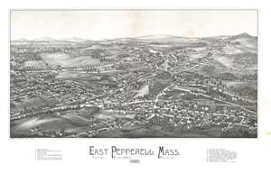
Easter Pepperell, Mass. 1886.
$950.00
Acquire
- Digital Map Information
- Suitable for large format printing
- File Size: 26.65 MB
- File Type: ZIP / TIFF
- ICC color profile embedded
- Delivered instantly via download link
This 1886 Lucian Rinaldo Burleigh bird's eye view map of East Pepperell, Massachusetts provides a look at a modern-day community near the end of the 19th century. Overlooking East Pepperrell from the southeast, several roads that still exist in town are illustrated and labeled, including Groton Street, Leighton Street, Mill Street, Tucker Street, and Hollis Street. Both the Nissitissit and Nashua Rivers are illustrated, and the Pepperell Covered Bridge across the Nashua River is illustrated to the right of center. Seventeen locations throughout town are numerically identified and correspond to an index below the bottom border, including several mills, two paper companies, the post office, train station, and public school. (more details)
Magnificent 19th century view of White Plains - one of only 3 known examples.
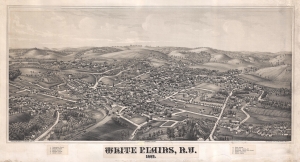
White Plains, N.Y. 1887.
$2,250.00
Acquire
- Digital Map Information
- Suitable for large format printing
- File Size: 18.84 MB
- File Type: ZIP / TIFF
- ICC color profile embedded
- Delivered instantly via download link
A fine example of Lucian Burleigh's extremely rare 1887 view of White Plains, New York. The map is oriented with northeast at top. It extends from Kensico Street (Now S. Kenisco Ave) to the conjunction of Banks Street and Fisher Avenue, and from the Bronx River to Old Post Road (Maple Ave). The viewpoint is from a low perspective somewhat southwest of the city. In an unusual exception to Burleigh's style, which restricts presentation to buildings and landscapes, and does not include people, animals, or carriages, the present map features a train entering the city from the southwest. Streets are labeled directly, and important buildings are identified numerically via a key in the lower margin. The view identifies five churches, public schools, the County Jail and Courthouse, a soldier's monument, and the railroad station. (more details)
Horse Racing and Hot Springs.
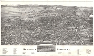
Saratoga Springs, N.Y.
$2,200.00
Acquire
- Digital Map Information
- Suitable for large format printing
- File Size: 69.16 MB
- File Type: ZIP / TIFF
- ICC color profile embedded
- Delivered instantly via download link
A striking 1888 Lucien Rinaldo Burleigh lithograph bird's-eye view of the spa town of Saratoga Springs, New York. (more details)
Layers of history in Bennington.
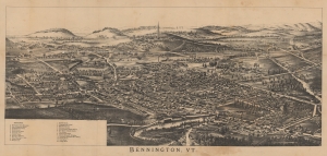
Bennington, VT. / Folded bird's-eye view of Bennington, VT. showing all points of interest.
$500.00
Acquire
- Digital Map Information
- Suitable for large format printing
- Full resolution TIFF file
- ICC color profile embedded
- Delivered instantly via download link
A c. 1890 bird's-eye view of Bennington, Vermont by Lucien Rinaldo Burleigh. It was likely published to coincide with the completion of the Bennington Battle Monument, which celebrated the American victory at the Battle of Bennington in 1777. (more details)