
Dai Nippon Printing (大日本印刷株式會社)

Dai Nippon Printing (大日本印刷株式會社; 1876 - present) is a Tokyo-based printing company with roots dating back to the Meiji era with the publisher Shūeisha (秀英舎), which developed a reputation for embracing new technologies and mechanization over traditional woodblock methods. In 1935, Shūeisha merged with Nisshin Printing (日清印刷), a publisher related to Waseda University, to form Dai Nippon Printing. In the postwar period, the company expanded further and was listed on the Tokyo Stock Exchange in 1949. In the mid-1950s, Dai Nippon was involved in printing the first editions of the Kōjien (広辞苑) dictionary, akin to Merriam-Websters in the United States or the Oxford English Dictionary in Britain, as well as Shukan Shincho (週刊新潮), long one of the most popular weekly news magazines in Japan. In subsequent years, the company branched out internationally and into other industries, including bottling Coca-Cola, but, like the publishing industry as a whole, has faced financial difficulties in recent years.
AKA: 大日本印刷株式會社
Gathering storm clouds over Europe, as seen from Japan.
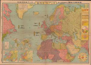
最新歐洲大地圖 (附列強國勢國防一覽) / [Latest Map of Europe (with an overview of the national strength and defenses of the major powers)].
$750.00
Acquire
- Digital Map Information
- Suitable for large format printing
- File Size: 80.15 MB
- File Type: ZIP / TIFF
- ICC color profile embedded
- Delivered instantly via download link
This is a very rare and unusual Japanese portrayal of European military power by Fuchida Tadayoshi - illustrated to support Japanese interest in the increasingly tense situation in Europe, as well as to emphasize to the Japanese public the value of European alliances. It was published as a supplement to the January 1, 1936 (Showa 11), edition of King (キング) magazine. The map, along with the included insets, charts, and graphs, describes the military and economic situation in Europe at the time and the relationship of Japan to the emerging European conflict. (more details)
The nadir of China's WWII experience.
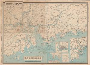
廣東香港明細地圖 ; 漢口南昌明細地圖 / [Detailed map of Guangdong and Hong Kong; Detailed map of Hankou and Nanchang].
$300.00
Acquire
- Digital Map Information
- Suitable for large format printing
- Full resolution TIFF file
- ICC color profile embedded
- Delivered instantly via download link
This is a pair of maps (front and back of the same sheet) from 1938 covering Guangdong, Hong Kong, and the Central Yangzi Region, including Hankou and Nanchang (now Wuhan), made during the Second Sino-Japanese War (World War II). It was published in King (キング) magazine, a popular general interest monthly. (more details)