
McIntyre, Henry

Henry McIntyre (fl. 1850s) was an American publisher of maps between 1850 and 1852. His surviving output focused exclusively on large city plans of New England towns - Boston, Lynn, Salem (1851), Danvers, Newburyport (1851), and Norwich, Connecticut - in spite of many of his works being actually printed in Philadelphia. It would appear that, like many more successful map and atlas publishers, McIntyre produced a handful of large, impressive maps either on a subscription model or as a speculative venture. The extremely short period of time during which McIntyre’s maps were produced suggests that his efforts were insufficiently fruitful. We find no trade advertisements for McIntyre’s map ventures in the newspaper record, and indeed, we find no biographical information for him whatsoever. (Perhaps had he been more assiduous at placing advertisements, this would not have been the case.) His offices were located at the N.E. Corner of Perry and Pine Streets, although which city these streets are/were in remain a mystery.
Newburyport at its height as a Maritime Center.
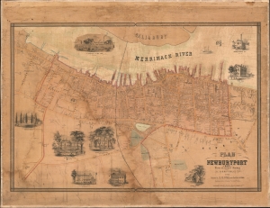
Plan of Newburyport, Mass. From an actual Survey by H. McIntyre C.E. 1851.
$2,000.00
Acquire
- Digital Map Information
- Suitable for large format printing
- DPI: 600
- File Size: 84.31 MB
- File Type: ZIP / TIFF
- ICC color profile embedded
- Delivered instantly via download link
A rare 1851 map of Newburyport, Massachusetts, produced by surveyor Henry McIntyre. The map captures Newburyport at the height of its prominence as a maritime center. This is a very scarce work by a local mapmaker. (more details)
Transitioning from a China Trade hub to a mill town.
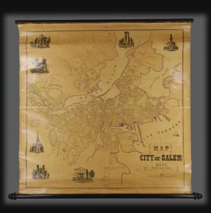
A rare 1851 map of Salem, Massachusetts, by civil engineer Henry McIntyre. The map is the second major map of Salem, following Jonathan Saunder's much smaller scale 1820 Plan of the Town of Salem. It marks Salem's transition from a maritime hub rich from the China and Pepper Trade to a mill and manufacturing center. (more details)