
Rapkin, John

John Rapkin (July 18, 1813 - June 20, 1899) was an English mapmaker and engraver. Born in Southwark, Rapkin was the son of George Rapkin, a shoemaker, and his wife Elizabeth Harfy. Rapkin and his brother Richard both became engravers and his other brother, William Harfy Rapkin, became a copperplate printer. Rapkin produced works for James Wyld and John Tallis, including The United States and the relative position of Oregon and Texas for Wyld around 1845, and a series of eighty maps for Tallis that became 'Tallis's illustrated atlas, and modern history of the world' in 1851. Rapkin married Frances Wilmot Rudell on January 4, 1837, with whom he had at least eight children, some of whom became engravers, including his sons John Benjamin Rapkin (1837 - 1914), Alfred Thomas Rapkin (1841 - 1905), Joseph Clarke Rapkin (1846? - 1912), and Frederick William Rapkin (1859 - 1945). Rapkin operated under the imprint 'John Rapkin and Sons from 1867 until 1883, and was operating as 'John Rapkin and Sons' by 1887. Rapkin died in 1899 at the age of 85 soon after the death of his wife of over sixty years.
India on the eve of the Mutiny.
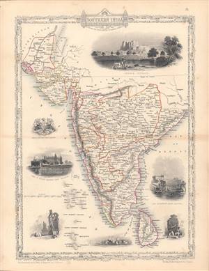
Southern India - including the Presidencies of Bombay and Madras.
$200.00
Acquire
- Digital Map Information
- Suitable for large format printing
- Full resolution TIFF file
- ICC color profile embedded
- Delivered instantly via download link
This is a rare 1851 map of India drawn and engraved by John Rapkin that appeared in Tallis's Illustrated Atlas and Modern History of the World. The map and illustrations reflect the recent Anglo-Sikh War (1845 - 1846) and show the divisions of the Indian subcontinent soon before the 1857 Mutiny and the inception of the Raj. (more details)
Highlights numerous gold claims across New South Wales at the beginning of the Australian Gold Rush.
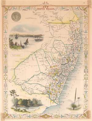
New South Wales.
$200.00
Acquire
- Digital Map Information
- Suitable for large format printing
- DPI: 600
- File Size: 7.9 MB
- File Type: ZIP / TIFF
- ICC color profile embedded
- Delivered instantly via download link
This is an 1850 John Tallis map of New South Wales, Australia highlighting the many gold claims peppered throughout the region. The map depicts eastern Australia from the Great Sandy Island south past Sydney to Cape Howe and extends a considerable distance inland despite the region being only tenuously mapped. Gold claims are marked by dashed lines and highlighted with bright gold colored ink. Beautiful illustrations by H. Warren depicting The Murray, a Xanthorrhaea (a plant endemic to Australia) and the Sydney Cove are also present. The seal of New South Wales is situated in the upper left corner. The map also notes the 1817 John Oxley's 1817 route is traced, along with that of Charles Sturt. The whole has the highly decorative presentation and elaborate border distinctive of Tallis maps. (more details)
Victorian London mapped as spectacle.
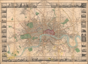
Tallis's Illustrated Plan of London and its Environs in commemoration of the Great Exhibition of Industry of all Nations, 1851.
$2,500.00
Acquire
- Digital Map Information
- Suitable for large format printing
- Full resolution TIFF file
- ICC color profile embedded
- Delivered instantly via download link
This is a superbly decorative 1851 John Tallis city plan of London, issued to commemorate the Great Exhibition and arguably Tallis's most ambitious single map. Touted on its release as 'the most beautiful and perfect Plan of London ever produced,' it makes a convincing case for the publisher's boast: John Rapkin's finely engraved plan is surrounded by an elaborate pictorial border of views depicting London's public buildings, monuments, and places of amusement. Both a practical city plan and lavish visual celebration of the Victorian metropolis, it captures London at a defining moment, when the Great Exhibition presented the city to the world as a center of industry, commerce, culture, and modernity. (more details)