
Rey, Marc-Michel

Marc-Michel Rey (May 5, 1720 - June 8, 1780) was a French Huguenot publisher, author, and bookseller active in the Amsterdam in the mid-18th century. Rey was born Geneva, Switzerland. Although he had little formal education, he was apprenticed to the Geneva bookseller Marc-Michel Bosquet from 1733 to 1744. Reaching he maturity, he relocated to Amsterdam, then the capital of the European book trade, where he purchased citizenship and commenced to publishing. Two years later, having quickly establishing himself in the rich Dutch market, he married Elisabeth Bernard, the daughter of a prominent Amsterdam bookseller, Jean Frederic Bernard (1680 - 1744), also of French Huguenot descent. Rey issued few maps, but in the exerted a strong influence on the publishing world. In the words of Utrecht Scholar Wijnand.W. Mijnhardt, 'The Bernard-Rey dynasty was a vital force in the French book trade on Dutch soil for almost 70 years, from 1711 until 1780.' (The Amsterdam booksellers Jean Frederic Bernard (1680-1744) and Marc Michel Rey (1720-1780)).
Muller's important map postulating a large peninsula in the North Atlantic.
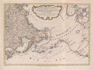
Nouvelle Carte des decouvertes Faites Par Des Vaisseaux Russiens Aux Côtes Inconnues de L'Amerique Septentrionale Avec Les Pais Adiacents.
$1,900.00
Acquire
- Digital Map Information
- Suitable for large format printing
- Full resolution TIFF file
- ICC color profile embedded
- Delivered instantly via download link
A beautiful example of Gerhard Friedrich Müller's important 1766 map of the Pacific Northwest, Alaska, the Bering Strait and Siberia, here in its rare Dutch second edition. Issued after the seminal explorations of Vitus Bering (1733 - 1743) on the Asia side of his namesake strait, but before the voyages of Captain James Cook similarly mapped the American side of the Bering Strait, this map is a smorgasbord of cartographic speculation – such as the exceptionally fine delineation of Friedrich Müller's Peninsula (Alaska / Aleutians). Centered on the Bering Strait, the map covers from Chinese Tartary to the Hudson Bay, and from the high Arctic, south as far as New Mexico, and Honshu (Japan). There is a striking contrast between the well explored Asiatic regions and the starkly bare and highly speculative mapping of America. (more details)