
Sauthier, Claude Joseph

Claude Joseph Sauthier (November 10, 1736 - 1802) was a French born surveyor, cartographer, and draftsman active in the British Colonies in North America just prior to the American Revolutionary War. Sauthier was born in Strasbourg, France, where he trained under Dezallier d'Agenvie and Jean Baptiste Alexandre le Blond as a garden designer and draftsman. He migrated to America in 1767 at the request of North Carolina royal governor William Tyron who was perhaps familiar with his book, A Treatis on Public Architecture and Garden Planning. Sauthier mapped much of the province of North Carolina before being promoted to the office of Surveyor of the Province of New York. Sauthier oversaw the surveying of numerous regional and provincial boundary disputes before the outbreak of the American Revolutionary War. During the Revolutionary War he was reassigned to the British Corps of Engineers, preparing an important survey for General Howe of New York and another of Staten Island. Sauthier was later attached to the staff of General Hugh Percy, who commanded the British Forces in Rhode Island. When Percy retired to his family estate, Alnwick Castle, in England, Sauthier accompanied him as a personal secretary. Ultimately, after a long, impactful, and adventurous career, Sauthier returned to his hometown of Strasburg where resided until his death on November 26, 1802. He was 66.
German interest in the American Revolution.
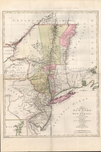
A Map of The Provinces of New-York and New-Jersey, with a part of Pennsylvania and the Province of Quebec from the Topographical Observations of C. J. Sauthier.
$2,250.00
Acquire
- Digital Map Information
- Suitable for large format printing
- DPI: 600
- File Size: 937.14 MB
- File Type: ZIP / TIFF
- ICC color profile embedded
- Delivered instantly via download link
An important 1777 Revolutionary War era map of New York and New Jersey by Claude Joseph Sauthier and Matthäus Albrecht Lotter. The map reflects significant German interest in the war related to widespread participation by Germans on both sides of the conflict. (more details)