
Sauthier, Claude Joseph (sold)

Claude Joseph Sauthier (November 10, 1736 - 1802) was a French born surveyor, cartographer, and draftsman active in the British Colonies in North America just prior to the American Revolutionary War. Sauthier was born in Strasbourg, France, where he trained under Dezallier d'Agenvie and Jean Baptiste Alexandre le Blond as a garden designer and draftsman. He migrated to America in 1767 at the request of North Carolina royal governor William Tyron who was perhaps familiar with his book, A Treatis on Public Architecture and Garden Planning. Sauthier mapped much of the province of North Carolina before being promoted to the office of Surveyor of the Province of New York. Sauthier oversaw the surveying of numerous regional and provincial boundary disputes before the outbreak of the American Revolutionary War. During the Revolutionary War he was reassigned to the British Corps of Engineers, preparing an important survey for General Howe of New York and another of Staten Island. Sauthier was later attached to the staff of General Hugh Percy, who commanded the British Forces in Rhode Island. When Percy retired to his family estate, Alnwick Castle, in England, Sauthier accompanied him as a personal secretary. Ultimately, after a long, impactful, and adventurous career, Sauthier returned to his hometown of Strasburg where resided until his death on November 26, 1802. He was 66.
Heart of British Strategy in the Revolutionary War.
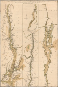
A Topographical Map of Hudsons River, with the channels depth of water, rocks, shoals etc. and the country adjacent, from Sandy-Hook, New York and bay to Fort Edward, also the communication with Canada by Lake George and Lake Champlain, as high as Fort Chambly on Sorel River.
sold
- Digital Map Information
- Suitable for large format printing
- Full resolution TIFF file
- ICC color profile embedded
- Delivered instantly via download link
This is Claude Joseph Sauthier's scarce, magnificent 1776 map of the Hudson River, Lake George, and Lake Champlain: the linchpin of Great Britain's strategy to swiftly achieve victory in the American Revolution. Control of the strategic New York - Montreal corridor would have divided the colonies effectively, allowing Britain to defeat the Revolution piecemeal. (more details)
Earliest Acquirable Printed Map to show Knox's Trail.
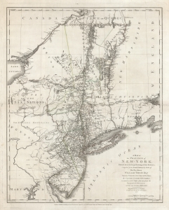
A Map of The Province of New-York, Reduc'd from the large Drawing of that Province, Compiled from Actual Surveys by order of His Excellency William Tryon Esq.r Captain General and Governor of the same, by Claude Joseph Sauthier, to which is added New-Jersey, from the Topographical Observations of C. J . Sauthier and B. Ratzer.
sold
- Digital Map Information
- Suitable for large format printing
- DPI: 600
- File Size: 82.53 MB
- File Type: ZIP / TIFF
- ICC color profile embedded
- Delivered instantly via download link
This is an important, detailed Revolutionary War era map focusing on the New York and Massachusetts theatres of the war, published in London by William Faden in August 1776, just after the Declaration of Independence. The map summarizes the best British surveys of the region available at the beginning of the Revolutionary War. It appears to be the first printed map to show the route taken by the 'Noble Train of Artillery,' which Henry Knox famously led from Fort Ticonderoga to Boston the previous winter, resulting in the expulsion of the British from that city. (more details)
German edition of Sauthier's influential Revolutionary War Era map of New York and New Jersey.
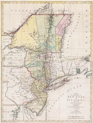
A Map of The Provinces of New-York and New-Jersey, with a part of Pennsylvania and the Province of Quebec from the Topographical Observations of C. J. Sauthier.
sold
- Digital Map Information
- Suitable for large format printing
- DPI: 300
- File Size: 23.99 MB
- File Type: ZIP / TIFF
- ICC color profile embedded
- Delivered instantly via download link
An important 1777 Revolutionary War era map of New York and New Jersey by Claude Joseph Sauthier and Matthew Lotter. This map is Lotter's German edition of Sauthier's map of 1776. The map covers from Quebec and Lake Champlain along the Hudson Valley Corridor ... (more details)