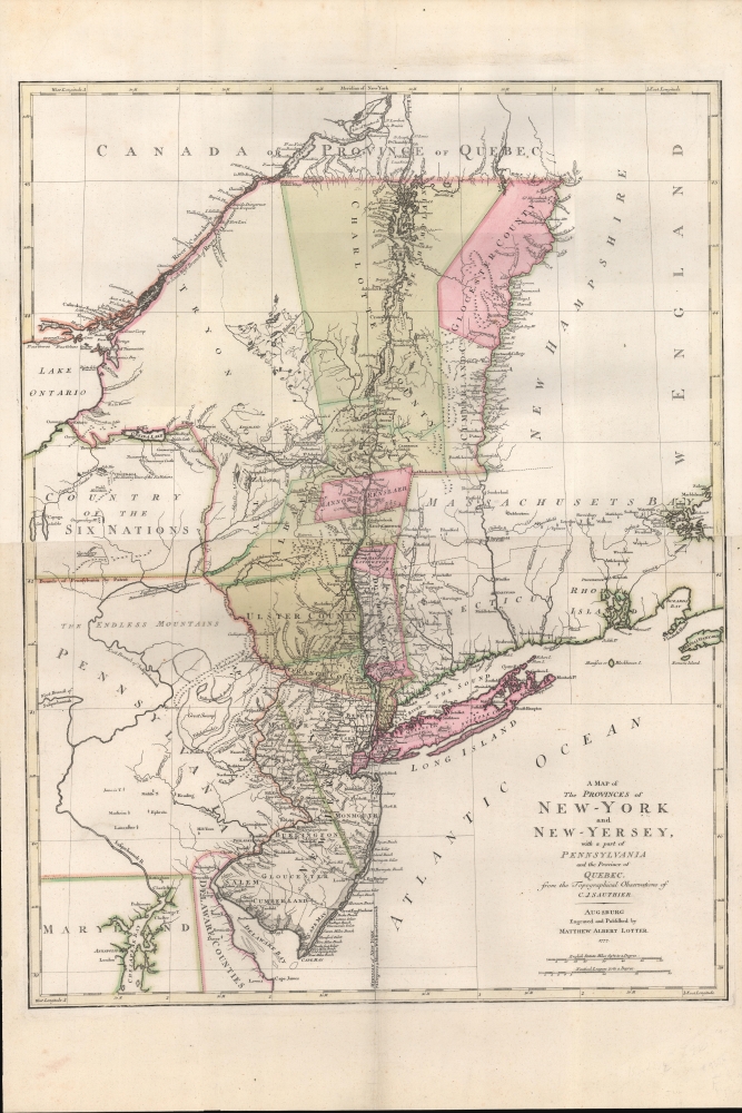
1777 Lotter and Sauthier Map of New York and New Jersey
NewYorkNewJersey-lotter-1777-2$2,250.00


Title
A Map of The Provinces of New-York and New-Jersey, with a part of Pennsylvania and the Province of Quebec from the Topographical Observations of C. J. Sauthier.
1777 (dated) 30 x 23 in (76.2 x 58.42 cm) 1 : 1000000
1777 (dated) 30 x 23 in (76.2 x 58.42 cm) 1 : 1000000
Description
An important 1777 Revolutionary War era map of New York and New Jersey by Claude Joseph Sauthier and Matthäus Albrecht Lotter. The map reflects significant German interest in the war related to widespread participation by Germans on both sides of the conflict.
The present example offers impressive detail in both New York and New Jersey with color coding identifying county lines. Topography, though minimal, is rendered in profile. The boundary line between East and West Jersey is noted as are various conflicting boundaries associated with the New York-New Jersey border dispute. The Tienaderha River (Unadilla River) marks the western frontier of colonial power in the region and recognizes the territory of the Six Nations Tribes - with various geographical features and American Indian villages noted. In Pennsylvania, just east of the Susquehanna, Sauthier identifies the 'Great Swamp'. Though modern residents of this region may have hard time recognizing it, there was once a vast wetland in modern day Bucks County. Today the much reduced 'Great Swamp' is called the Quakertown Swamp and is a protected wetland popular with birders.
A Closer Look
This is Lotter's German edition of Sauthier's map of 1776, with coverage embracing from Quebec and Lake Champlain along the Hudson Valley Corridor south as far as Delaware Bay, inclusive of all of New York (as it then appeared) and New Jersey, as well as significant portions of adjacent Pennsylvania, Massachusetts, Connecticut, and Delaware. Vermont is here attached to New York, as it was at this time legally part of New York (as shown), although practically under the control of the New Hampshire land grantee Ethan Allen and his Green Mountain Boys.The present example offers impressive detail in both New York and New Jersey with color coding identifying county lines. Topography, though minimal, is rendered in profile. The boundary line between East and West Jersey is noted as are various conflicting boundaries associated with the New York-New Jersey border dispute. The Tienaderha River (Unadilla River) marks the western frontier of colonial power in the region and recognizes the territory of the Six Nations Tribes - with various geographical features and American Indian villages noted. In Pennsylvania, just east of the Susquehanna, Sauthier identifies the 'Great Swamp'. Though modern residents of this region may have hard time recognizing it, there was once a vast wetland in modern day Bucks County. Today the much reduced 'Great Swamp' is called the Quakertown Swamp and is a protected wetland popular with birders.
Historical Context
This map is essentially a summary of mapping in New York completed by the British Corps of Engineers in the years just prior to the outbreak of the American Revolutionary War (1775 - 1783). Sauthier was the official surveyor of the province of New York from 1773 to 1776, a period that witnessed numerous boundary disputes both within the colony and with neighboring Quebec, New Hampshire, New Jersey, Pennsylvania, and Massachusetts. These disputes fostered a wealth of new survey information and encouraged a careful re-examination of older survey work - most of which was accomplished by Sauthier and those under him. When Sauthier briefly returned to London in 1774, he met with William Faden to publish a new, definitive map of the region - the 1776 first edition.German Interest in the American Revolution
In the early years of the Revolutionary War, the ethnically German King of England, George III, called on his resources as Prince-elector of Hanover, a title which he held concurrently with his British titles, to field numerous German soldiers in defense of his claims in America. On the Continental side, pre-war German immigration led to the formation of the Provost Corps in Pennsylvania and the German Regiment. Other Germans fought for American independence under the French Flag. The significant presence of German forces on both sides of the conflict fostered a wide interest throughout German lands in the unfolding war in the Americas. Lotter was quick to capitalize on this interest with the 1777 republication of Sauthier's important map, essentially the most up to date map of the region available at the time.Publication History and Census
This map was engraved and published by Matthäus Albrecht Lotter in Augsburg. It was sold individually, as well as included in some editions of Seutter's Grosser Atlas, published by Lotter in 1778, as well as in some examples of Seutter's Atlas Novus, and in various composite atlases of the period.CartographerS
Claude Joseph Sauthier (November 10, 1736 - 1802) was a French born surveyor, cartographer, and draftsman active in the British Colonies in North America just prior to the American Revolutionary War. Sauthier was born in Strasbourg, France, where he trained under Dezallier d'Agenvie and Jean Baptiste Alexandre le Blond as a garden designer and draftsman. He migrated to America in 1767 at the request of North Carolina royal governor William Tyron who was perhaps familiar with his book, A Treatis on Public Architecture and Garden Planning. Sauthier mapped much of the province of North Carolina before being promoted to the office of Surveyor of the Province of New York. Sauthier oversaw the surveying of numerous regional and provincial boundary disputes before the outbreak of the American Revolutionary War. During the Revolutionary War he was reassigned to the British Corps of Engineers, preparing an important survey for General Howe of New York and another of Staten Island. Sauthier was later attached to the staff of General Hugh Percy, who commanded the British Forces in Rhode Island. When Percy retired to his family estate, Alnwick Castle, in England, Sauthier accompanied him as a personal secretary. Ultimately, after a long, impactful, and adventurous career, Sauthier returned to his hometown of Strasburg where resided until his death on November 26, 1802. He was 66. More by this mapmaker...
Tobias Conrad Lotter (1717 - 1777) was a German engraver and map publisher. Lotter was the son of a baker and city guardsman, but married Euphrosina (1709 - 1784) Seutter, elder daughter of the prominent map publisher Matthäus Seutter. He began working at his is father-in-law's map business about 1740. Between 1740 and 1744 he produced, under Seutter's imprint, the Atlas minor, Praecipua orbis terrarum imperia, regna et provincias, Germania potissimum tabelli. Upon Seutter's death, in 1757, the firm's stock was taken over by his son, Albrecht Karl Seutter (1722 - 1762), who himself died in 1762, just a few years later. The remaining Seutter map plates were subsequently divided between Lotter and the publisher Johan Mitchell Probst (1727 - 1776). With the support of his sons, Matthäus Albrecht (1741 - 1810), Georg Friedrich (1744 - 1801) and Gustav Conrad (1746-1776), Tobias Conrad Lotter succeeded in building on the economic success and professional reputation of his father-in-law. In time, Lotter became one of the most prominent mid-18th century map publishers working in the German school. After Lotter's death in 1777, the business was taken over by his two eldest sons, who, lacking their father's business acumen, presided over the firm's slow decline. It was nonetheless passed on to a subsequent generation of Lotters, Matthäus Albrecht Lotter's sons, Gabriel (1776 - 1857) and Georg Friedrich (1787 - 1864), who pushed it into further decline until it faded out in the early-19th century. Learn More...
Source
Seutter, M., Grosser Atlas, (Augsburg: Lotter) 1778. Also, Seutter, M., Atlas Novus, (Augsburg: Lotter) 1778.
Condition
Very good. Laid on linen.
References
New York Public Library Map Div. 01-1836. Brooklyn Collection, Brooklyn Public Library, Document 51. Bulletin of the New York Public Library, Vol 4, 1902, Page 86. McCorkle, B.B., New England in Printed Maps 1513-1800: An Illustrated Carto-Bibliography, #777.20. Boston Public Library, G3800 1777 .S28.