
Spangenberg, Charles L.

Charles Spangenberg(fl. c. 1862 - 1872) was a topographical draftsman active in the mid to late 19th century. Spangenberg served with the Union Army during the American Civil War (1861 - 1865). His name is attached to at least one important Civil War manuscript maps, of the Battle of Vicksburg, as well as published maps of multiple other battles. After the war, he was active in New York City, where he drew several maps for the New York Parks Commission.
First Battle of Corinth.
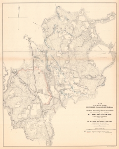
Map of the Country Between Monterey, Tenn. And Corinth,Miss. Showing the Lines of Entrenchments Made and the Routes Followed by the U.S. Forces under the Command of Maj. Gen'l. Halleck, U.S. Army, in Their Advance Upon Corinth, in May 1862.
$500.00
Acquire
- Digital Map Information
- Suitable for large format printing
- File Size: 78.4 MB
- File Type: ZIP / TIFF
- ICC color profile embedded
- Delivered instantly via download link
This is a separate issue 1862 Otto H. Matz map of American Civil War troop movements leading to the capture of Corinth, Mississippi, in May 1862. The map depicts from Cane Creek and the Tuscumbia River to Springer, Tennessee and Johnston, Mississippi and from Monterey, Tennessee to the George homestead in Mississippi. (more details)
New York City Hall.
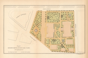
Plan of Improvements of City Hall Park.
$350.00
Acquire
- Digital Map Information
- Suitable for large format printing
- File Size: 3.46 MB
- File Type: ZIP / TIFF
- ICC color profile embedded
- Delivered instantly via download link
A scarce 1871 map of City Hall Park in New York City by Kellogg and Pilat. (more details)